Watchful eyes on Beryl for potential Texas impacts
BRYAN, Texas (KBTX) – As Beryl batters Jamaica, eyes are now turned toward the Cayman Islands, then to the Yucatan peninsula, then to the Gulf of Mexico.
What happens with each step of this westward track will play a role in exactly where its ultimate landfall is, whether Mexico or Texas.
As #Beryl exits #Jamaica, its intact eyewall is now in range of the #CaymanIslands radar… handing off coverage from Cuba. https://t.co/pK3EMVTVvY pic.twitter.com/H1jaKVR9BK
— Brian McNoldy (@BMcNoldy) July 3, 2024
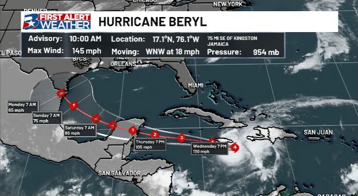
As of the Latest update from the National Hurricane Center:
Beryl has not weakened quite as much as expected, even with unfavorable upper level winds and interaction with land (Jamaica). While Jamaica may avoid a direct landfall, this land interaction/topography will act to weaken the storm at least a little bit, but a brief window for strengthening will open up as it clears Jamaica and moves over or near the Caymans en route to the Yucatan Peninsula.
After this evening, the biggest key to figuring out whether this is a Texas or Mexico storm begins to turn.
What’s next?
A Hurricane Warning is in effect for Jamaica, as well as Grand Cayman, Little Cayman, and Cayman Brac. The warning has thus been extended to the East coast of the Yucatan Peninsula of Mexico.
Beryl continues its west-northwest path, with a well-established ridge over the southern US this track will continue to steer Beryl across the Caribbean toward The Caymans and then the Yucatan Peninsula. The forecast “cone of uncertainty” now includes a significant portion of Southern Texas, with the outermost part of the track about 50 miles away from the southern tip of the Brazos Valley.
Texas impacts
A ridge of high pressure will play a large role in what exactly Beryl does once it does moves into the Gulf. This ridge is expected to weaken as we approach the weekend, and move eastward. Ahead of ANY potential interaction with Beryl, this will open the door for a trough of low pressure to usher in showers and storms from North Texas to the coast, including our area.
We expect the Beryl picture to become a LOT clearer in the next several days, as its interaction with the Yucatan Peninsula is crucial in predicting whether a Texas landfall happens.
From there, additional moisture from Beryl, or rain bands from the storm itself, could come into the state right as the holiday weekend is ending and we start next week. Between land interaction, track, and strength of Beryl, it is too early to know specific impacts, but at least some appear more likely, with rough surf/waves expected along the coast.
What to watch
• Path Beryl takes now through Friday evening over Yucatan Peninsula
• Strength of Beryl as it re-emerges in the Gulf of Mexico
Both the intensity and movement of Beryl will play a huge role in whether Texas and the Brazos Valley see impacts from this storm. A more northward track, combined with a stronger Beryl, would mean more rain and wind locally. Should Beryl not make direct landfall over the Yucatan (more northward movement), or only skirt the northern tip of the peninsula, that would likely result in less weakening of the storm, bringing a greater concern for a Texas hurricane landfall. While this is in the realm of possibilities, it appears to be the less likely scenario as of right now.
We expect the Beryl picture to become a LOT clearer in the next several days, as its interaction with the Yucatan Peninsula is crucial in predicting whether a Texas landfall happens.
A southerly track is more favored, and would likely reduce impacts and overall strength of the storm. At the moment, we are expecting Beryl to make landfall anywhere between the northern Mexico coast to the Middle Texas Coast. This is still very large spread, so confidence in potential Texas impacts remain low, come the end of the week, however, forecasts may start to become more clear.
To re-iterate, the picture will become steadily more clear in the coming days, but we will have a much better idea on where this storm will go Friday evening into Saturday.
We expect the Beryl picture to become a LOT clearer in the next several days, as its interaction with the Yucatan Peninsula is crucial in predicting whether a Texas landfall happens.
Where do we go from here? Watch, wait, monitor trends, and remain calm. As of Wednesday afternoon, we still have no major concern for the Brazos Valley. Rainfall forecasts will largely depend on the above (strength and path of the storm).
As we get more information and confidence in the forecast, we will, of course, keep you updated. Regular updates can be found on air, online, and on your First Alert Weather app. If you want to track the storms along with the team you can pick up the 2024 First Alert Weather Team Hurricane Tracking Chart at any of our sponsors, or download it here!