Tuesday broke a 108 year old record high. Let’s put November 7th into perspective
BRYAN, Texas (KBTX) – October ended as the eighth warmest of record in Bryan-College Station’s 141 years of record keeping, tying 1892 for a top 10 place. After a short chill to end October and kick off the eleventh month of the year, November is feeling more like September across much of the United States currently. Several cities across the Lower 48 have reported either tying or setting new record highs Monday and Tuesday, from Arizona to New Mexico, to Northwest Texas, and east to Nashville, Tennessee. Bryan-College Station was added to that list Tuesday after the thermometer climbed to its highest point since 1915.
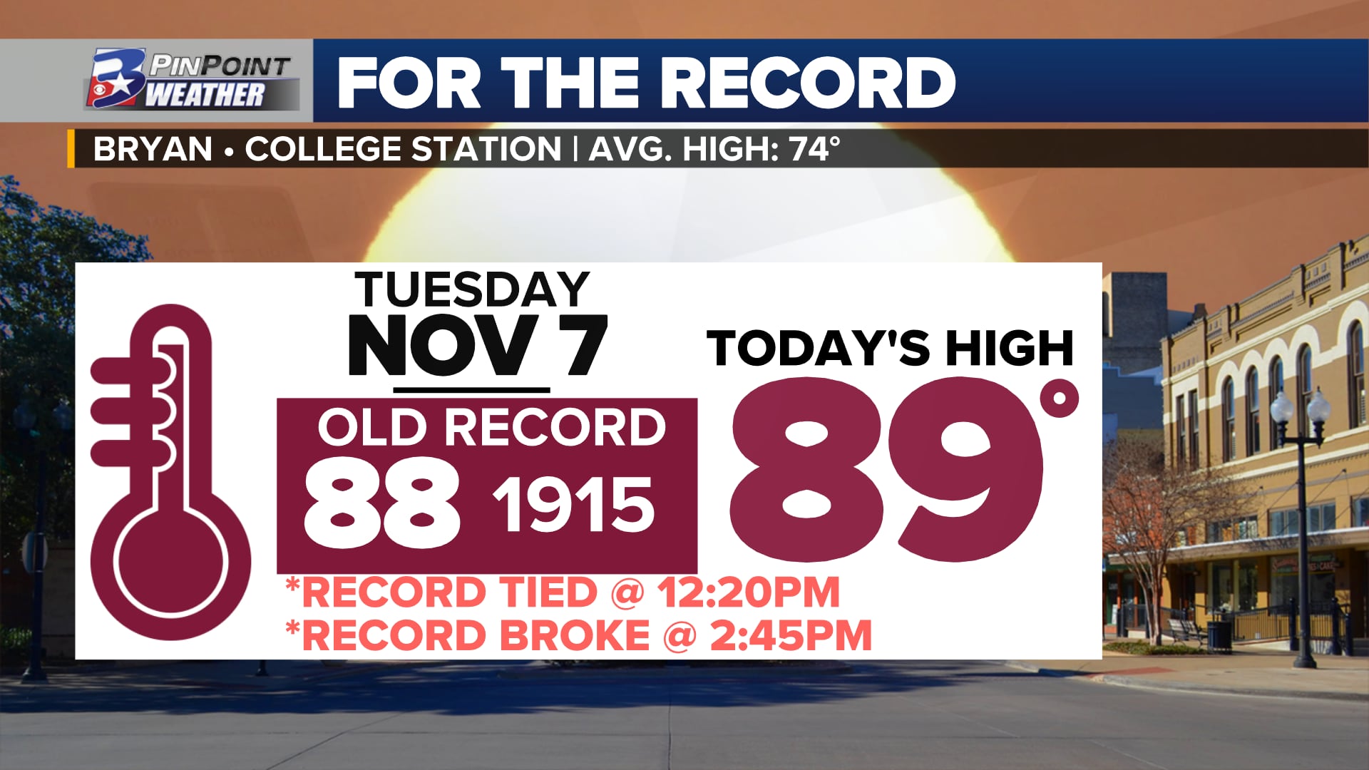
OLD RECORD BROKEN. ANOTHER 2023 RECORD SET
It only took until 12:20 p.m. for the official reporting site at Easterwood Airport to reach and tie November 7th’s all-time hottest temperature of record. Two hours and twenty-five minutes later, the temperature briefly jumped to 89°, breaking the day’s previous record high from 1915. After falling back to 88°, the thermometer officially touched the new record mark one more time, shortly after 3 p.m. Under a clear blue sky, Bryan-College Station experienced record warmth of three hours and fifty-five minutes Tuesday.
HOW COMMON IS AN 80° DAY ON NOVEMBER 7th?
Weather records have been kept in Bryan-College Station since 1882. Tuesday’s high made this the 40th time that a high temperature of 80° or warmer has been experienced on this day in the 141 years of records. 28% of all of the 7th day of November recorded have warmed to a high in the 80s. The most recent before this year? 2022 when the high temperature reached 87°, tying as the second hottest November 7th of record.
Since 2005, the top five warmest temperatures of record for this date have been experienced five times. Since 2000, an 80° high temperature has been recorded nine times for this date. Nearly 40% of all November 7ths since the start of this millennium.
WHAT CAUSED TUESDAY’S RECORD WARMTH?
High pressure in the Northern Gulf of Mexico is pumping moisture into the lowest levels of the atmosphere. At the same time, breezy south winds up to 25mph have been moving warmer air into the Brazos Valley, Southeast Texas, and — really — much of the Lower 48.
Warmer-than-average temperatures are being experienced across much of the US in this current weather pattern
In a very classic El Niño set-up, the southern branch of the jet stream is tilted from the southwest to the northeast, running from the Pacific Ocean over Texas. This allows tropical moisture to fill the mid and upper levels of the atmosphere. As the next weather maker digs down the Western US, this typically allows temperatures to run abnormally warm.
While very common to find warmer-than-average temperatures in a weather pattern such as this, even these temperatures are abnormally high. High temperatures climbed as much as 15° above what is typical in early November Tuesday. This is a feat that will be repeated Wednesday as afternoon temperatures are expected to top off a degree shy of November 8th’s 38-year-old record of 89°. Despite different weather patterns, 2022 pulled off similar warmth during this part of the year — and that was during a La Niña fall.
Climate Shift Index for November 7th across the Lower 48
Attribution Science tells us that human-induced climate change — both by adding excessive carbon into the atmosphere and through aiding the urban heat island effect — has added that extra bit of warmth to early November. Temperatures experienced on this date both last and this year are now 1.5 times more likely to occur because of these impacts. This means there is a moderate detection of climate change’s impacts.
COOLER AIR RETURNS BY THE END OF THE WEEK
After another near-record day of warmth Wednesday, the next round of fall air is expected to slip into the Brazos Valley Thursday afternoon. Temperatures are expected to fall to the slightly above-average mid/upper 50s for lows through the start of next week, while afternoon highs top off below-average in the 60s.
FALL AIR RETURNS THURSDAY!
Next cold front is scheduled to slowly sink into the Brazos Valley between lunchtime & early evening. Once the front arrives:
• Wind gusts 20-30mph
• Temp drops ~10° in first hour
• Widespread rain fills in behind
#bcstx pic.twitter.com/cpJkGIRyiW
— Shel Winkley 👍 (@KBTXShel) November 8, 2023
The same weather pattern that is creating this November warmth is also providing ample moisture to work with to make rainfall once this cold front arrives. The atmospheric value of moisture to make rain is currently running 200% to 250% of what is typical at this time of the year. Widespread rain starting Thursday and ending Friday morning will bring the potential of 0.5″ to 1.5″ of rain areawide, with localized 2″+ totals possible.