Tropics waking up, including an area to watch in the Gulf of Mexico
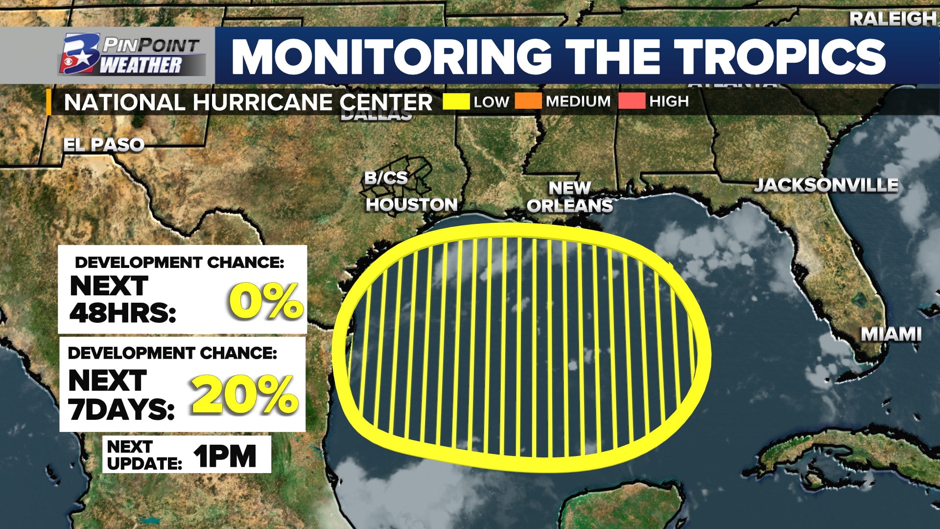
BRYAN, Texas (KBTX) – Eyes on the Gulf. For the first time this season, the National Hurricane Center has placed an “area of interest” on the Central, Northern, and Western reaches of the basin to be monitored over the next five to seven days. As of the Wednesday morning update from the agency, the odds of tropical development are currently low, listed at a 20% chance through next Wednesday.
WHAT WE KNOW
An area of low pressure is expected to move off the western tip of Cuba this weekend, likely Sunday. This feature will be driven west through the Gulf of Mexico by a much, much larger dome of high pressure over an expansive portion of the Central and Eastern Lower 48.
A large high pressure system over the Central and Eastern US will drive this potential tropical system west through the Gulf by the weekend through early next week
Wednesday’s data has unfortunately brought less consistency, and therefore less certainty regarding next week. A strong ridge of high pressure is expected to setup just north of Texas, and the strength and exact position of that ridge isn’t set in stone yet. That, along with several possible tracks of any tropical system (regardless of strength) leave a lot in the air for next week.
For the first time this season, there are three areas to watch, as outlined by the NHC. Of most interest locally is a large area in the Gulf of Mexico.
Gulf of Mexico water temperatures are running anomalously warm, even for this time in late summer. Surface temperature has been measured between 85° and 90°. Earlier this week, the average temperature of the Gulf was noted to be the warmest on record. This is certainly warm enough to fuel a tropical system as it moves westbound.
Opposite of those exceptionally warm Gulf waters, the mid-levels of the atmosphere could have this potential system struggling to form. A plume of Saharan Dust is expected to reach the area this weekend through next week, hindering the chance for thunderstorms to develop over the open waters. This could be the greatest limiting factor that keeps a fully tropical low from forming.
ALL THE UNCERTAINTIES
The European forecast model is the most aggressive when it comes to any sort of development potential with this weather system. The latest ensemble data has increased the probability of a tropical depression forming to a 50% – 70% chance. This new data, for the first time, also places a low 10% to 20% potential that a tropical storm could form before moving inland over the Western Gulf of Mexico.
/3 One particular version of ensemble guidance now points to a 50% to 70% chance of at least a Tropical Depression attempting to form in the Gulf of Mexico by early next week.
New today: very LOW odds (<20%) for something tropical storm strength before moving inland pic.twitter.com/Ylra7YCgLU
— Shel Winkley 👍 (@KBTXShel) August 15, 2023
That said, the American GFS forecast ensemble model has yet to show this weather maker being any more than just that. It has not shown any signs of a tropical system forming on any data run up to this point.
It is still early. While data is pointed toward the Western Gulf of Mexico, shifts should be and are expected over the next three to five days.
NOT THE ONLY TROPICAL SYSTEM IN THE GULF?
New Tuesday, the Climate Prediction Center also weighed in on the Gulf of Mexico. Forecasters placed a low confidence, greater-than-20% probability that a tropical system could form somewhere in the basin between Wednesday, August 23rd and Tuesday, August 29th.
The Climate Prediction Center has placed a second chance for tropical development somewhere in the Gulf of Mexico before the end of August
While there have been signals from multiple ensemble forecast models for this potential tropical activity, nothing is certain as this point a week and a half to two weeks out. Nothing of concern for the Gulf Coast, and no reason to be hopeful for needed rain from a system yet. Rather, just a forecast to keep an eye on before the end of August.
OTHER TROPICAL ACTIVITY TO MONITOR IN THE ATLANTIC
Forecasters at the National Hurricane Center are also monitoring two tropical waves in the Eastern Atlantic Ocean.
For the first time this season, there are three areas to watch, as outlined by the NHC. Of most interest locally is a large area in the Gulf of Mexico.
Here’s the latest from the agency regarding these two areas to monitor in the Tropical Atlantic and near the coast of Africa:
Central Tropical Atlantic
Eastern Tropical Atlantic