Tropical Storm conditions expected for the Brazos Valley Monday
BRYAN, Texas (KBTX) – Following a long journey across the Caribbean and a very short stay over the Yucatan Peninsula, Beryl has a few more hours in the Gulf of Mexico before it makes landfall over the Coastal Bend of Texas, with a path directly through the Brazos Valley shortly after.
Biggest change to the forecast: With Beryl’s forecast path more certain, and additional strengthening possible, the wind threat due to expected tropical storm conditions has increased for the area.
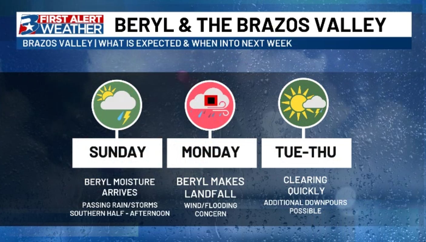
With Tropical Storm Beryl expected to pass right through the Brazos Valley Monday, the wind and flooding threat for the area has increased. Strongest wind will be felt through the first half of the day Monday, along with the heaviest rounds of rain.
TIMELINE OVERVIEW:
As we wrap up the weekend, we will see our first impacts from Beryl as the storm inches closer to the Texas coastline. Sunday will be a big day for fine tuning of the forecast, and checking on our coastal friends to make sure all preps are underway and completed before the afternoon. For local folks: This is a day to make sure all loose lawn furniture is brought in, along with any outdoor items around the house to be secured, as wind will be a factor through most of the day Monday.
While the forecast has been one of wet weather for much of next week, we still expect a large portion of the area (especially along and east of Highway 6) to receive a lot of rain, especially on Monday.
With Tropical Storm Beryl expected to pass right through the Brazos Valley Monday, the wind and flooding threat for the area has increased. Strongest wind will be felt through the first half of the day Monday, along with the heaviest rounds of rain.
First bands from Beryl may arrive in the Brazos Valley as early as Sunday afternoon. Wind will pick up as Beryl gets closer to the area, but we likely won’t feel the wind impact from Beryl until Monday morning. Monday looks to be the windiest day, but exactly HOW windy we get is entirely dependent on Beryl’s strength at landfall. Within some isolated storms, some strong wind gusts will also be possible.
WHAT TO MONITOR
Ahead of landfall, the Brazos Valley has been placed under multiple advisories. The majority of the area is under a Flood Watch until Tuesday morning. Heavy rainfall associated with Beryl is expected to pose a flash flooding threat for a large portion of southeast Texas. Rainfall totals of 5″-10″ with some locally higher totals are possible within the watch area, those totals highly depend on the exact track of Beryl.
Locally widespread amounts of 3-5″ (mainly falling on Monday) with localized totals of 7″ or more still look possible. If the track continues to nudge itself EASTWARD, these numbers WILL come down. A more western track will put the Brazos Valley in the middle of some of the heaviest corridors of rainfall, and will likely leave behind higher totals.
With Tropical Storm Beryl expected to pass right through the Brazos Valley Monday, the wind and flooding threat for the area has increased. Strongest wind will be felt through the first half of the day Monday, along with the heaviest rounds of rain.
In addition to heavy rainfall, the threat for damaging wind gusts have also increased. A Tropical Storm Warning has been issued for portions of the Texas coastline has has been extended northward to include Waller and Austin Counties. This means there is a threat of tropical storm force winds are expected within the area. The window for our local counties to experience these are mainly focused Monday. While the current hope and thought is winds will not be quite to this strength, some scattered power outages due to wind cannot be ruled out at this time.
As many will be to the east of the center of circulation of this storm, we cannot rule out a couple brief spin-up tornadoes. Typically, these are few and far between and relatively weak, but it is one of the things we will watch closely, especially Monday during the daytime hours.
The good news: We should begin to wrap up these tropical storm conditions quickly as we head into Monday night and Tuesday. Updates can of course be found here, on your First Alert Weather app, and on-air throughout the rest of the weekend and into next week.
With Tropical Storm Beryl expected to pass right through the Brazos Valley Monday, the wind and flooding threat for the area has increased. Strongest wind will be felt through the first half of the day Monday, along with the heaviest rounds of rain.