Thursday’s rain drenched some, grazed others
BRYAN, Texas (KBTX) – October is a big month of rain for the Brazos Valley. Well, typically. The tenth month of the year is expected to be the wettest with right around 5″ expected in Bryan-College Station. Thursday morning, before rain started to fall in the area, Easterwood Airport was behind of rainfall with a month-to-date deficit of 1.78″. By the end of the day, that deficit was only able to be closed by 0.74″. Still, other parts of the area watched water fill up low-lying area and streets as it fell at a clip of over 1″ per hour.
Already some pretty significant flooding in Milam County this afternoon.
📍Williams Trace Apartments
Cameron, TX pic.twitter.com/OnbFojGGUo
— Berkeley Taylor (@KBTXBerkeley) October 26, 2023
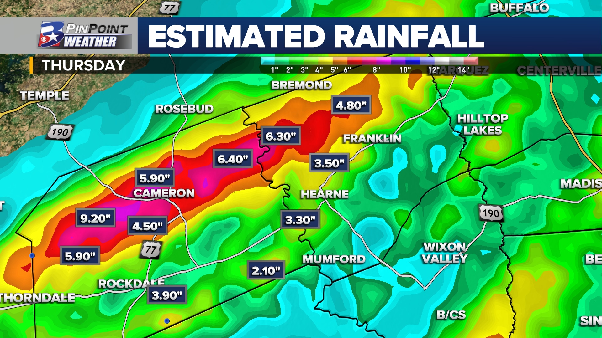
A Flash Flood Warning was issued for Milam County Thursday morning as training, heavy rain moved in from the west and stalled through lunchtime. The result was a radar estimate of half a foot of rain to over nine inches of rain across the northern tier for the county. The highest rainfall total of the day was located just north of the community of Sharp, along FM 486 and south of FM 1915. That same band of heavy rain left behind between 3.5″ and 6″ of rain over north-northwest Roberston County, between the Brazos River, Calvert and East FM 979.
Bryan-College Station’s heaviest rain fell from Deacon Drive to the south end of town. Tower Point, at the corner of Highway 40 and Highway 6, is estimated to have received just over 3.25″. Officially, rainfall for October, compared to average for this time of the month, is now behind by a little over 1″.
Rainfall totals from reporting stations across the Brazos Valley
Below is a collection of rainfall reports from official reporting stations and Weather Watchers across the Brazos Valley Thursday:
College Station (Easterwood Airport): 0.74″Bryan (Coulter Field): 0.23″Kyle Field (Texas A&M University): 0.92″Texas A&M University West Campus: 0.93″The Gardens at Texas A&M University: 0.51″South College Station (Long Creek Lane): 2.70″South Bryan: 0.55”Millican: 0.89″South Brazos County (South Nantucket): 1.75″Southwest Brazos County (River Run Subdivision): 0.80″Edge: 2.50″Milam / Roberston County line (Brazos River Gauge at FM 485): 1.43″Hearne: 1.62″Brenham: 1.25″Caldwell: 0.19″Cameron: 3.24″Milam County (Gauge at the Little River at Highway 36): 4.87″Robertson / Leon County line (Navasota River Gauge at OSR): 1.44″Buckholts: 2.56″Centerville: 0.90″Madisonville: 2.43″Huntsville: 3.72″Elkins Lake: 3.68″Trinity: 1.20″Crockett: 0.73″Coldspring: 1.17″Conroe: 1.63″Hempstead: 3.44″Navasota: 1.35″Bellville: 2.95”Anderson: 0.66″Grimes County (Mill Creek at FM 1774): 4.36″Grimes County (Gibbons Creek): 0.59″Northeast Brazos County (8 miles north of Kurten / 4 miles west of Edge): 1.40″Roans Prairie: 1.00″Washington County (Between Brenham & Chappell Hill): 1.65″Flynn: 1.60″ Benchley: 0.72″Canary: 2.10″Walker County (between Huntsville & Phelps: 4.64″Riverside: 4.50″Camp Creek: 1.80″West Madison County (between Edge & Normangee): 3.25″Normangee: 1.75″Chriesman: 1.56″Franklin: 2.50″Roberston County (south of Franklin, north of Wheelock): 0.53″Iola: 1.65″Flamingo Lake (Lake Conroe): 4.11″Lake Conroe (FM 1907): 6.28″Dobbin: 3.81″Montgomery: 2.50″
Have a total from your rain gauge after Thursday’s rainfall? Email it to weather@kbtx.com