Rain returns to the Brazos Valley for October’s finale
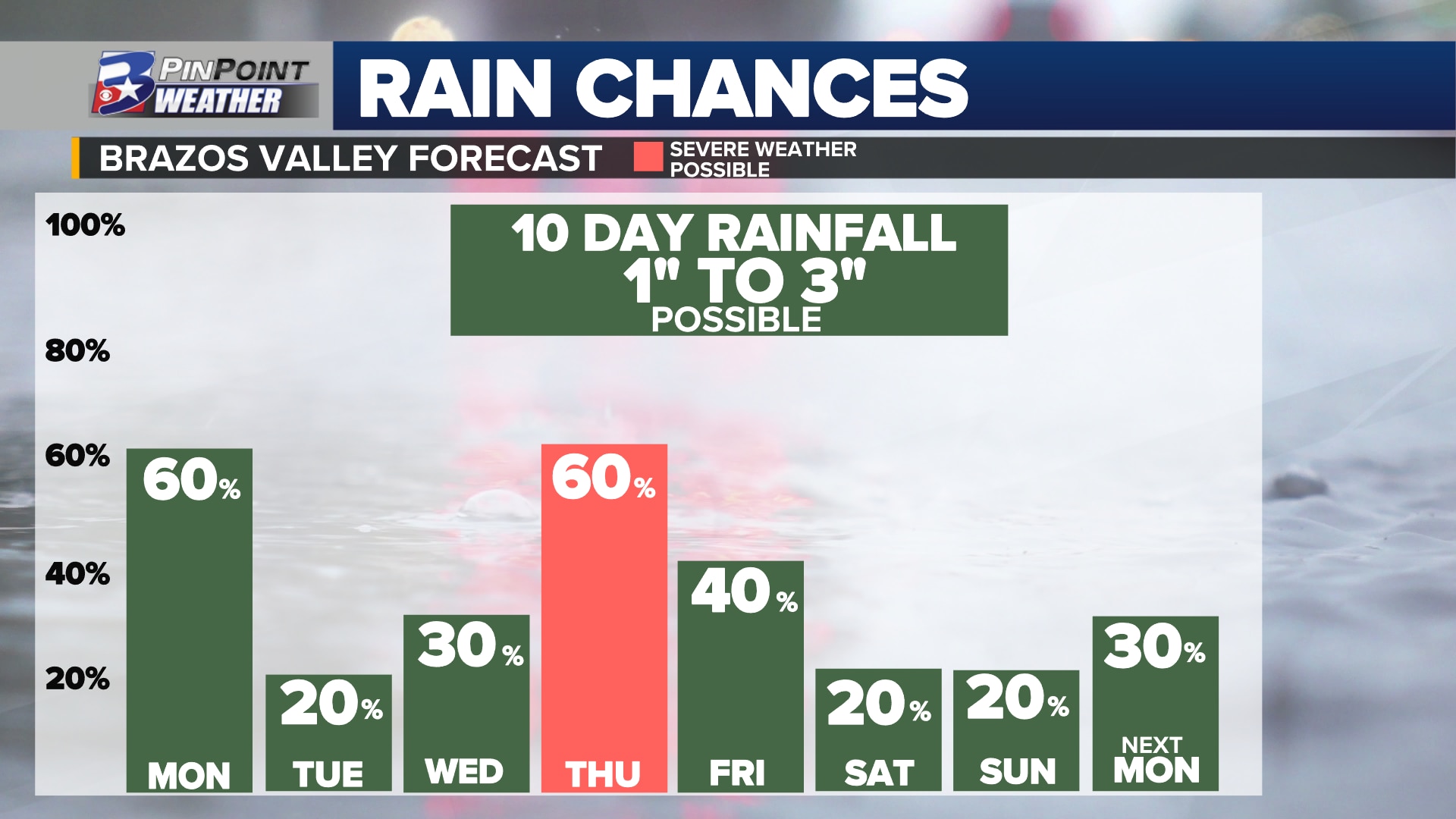
BRYAN, Texas (KBTX) – Rain is back in the Brazos Valley’s forecast, stretching through the last days of October. While it is not expected to fall every day, everywhere, the prospect of wet weather is in the outlook to some degree through Halloween. The next 10 days could leave behind as much as 1″ to 3″ of needed moisture. October, typically the wettest month of the year, is currently running dry. Bryan-College Station has 2.32″ in the rain gauge so far, running behind the month-to-date average by a little over 1″.
MONDAY
A small, compact area of rain-making moisture will have spent the night crawling north out of the Gulf of Mexico. As it passes through the Brazos Valley before noon, it will likely allow for scattered showers to pass north with it.
Compact slug of rain-making moisture is headed toward the Texas Coast tonight
Quick pass through the Brazos Valley will bring a shot at scattered showers as we kick off the new week. Not for all of us — won’t leave much behind in the rain gauge (0.1″ – 0.5″ at best) pic.twitter.com/0sbe5gSKTq
— Shel Winkley 👍 (@KBTXShel) October 23, 2023
The best chance for rain comes between 8am and 11am, moving from the south to the north. While rain will not fall for everyone, those who manage to find a passing shower could snag anywhere from 0.1″ to 0.5″ in the gauge. A low-end, 20% chance for a spot shower lingers through the afternoon. Good news, rain or not? Clouds and the morning rain chance should hold afternoon highs sub-90°!
TUESDAY – WEDNESDAY
Not a whole lot to report here, but a few spots of rain are certainly not out of the question. The remnants of what was once Hurricane Norma in the Pacific will be pulled over parts of Northwest Texas. That area of the state could drink up as much as 5″ or more of rain! Locally, a 20% chance for showers west of the Brazos River and a 30% chance for scattered, spotty rain is the best that can be mustered locally. Wednesday will be the windiest day of the week — 15 to 20mph — ahead of the next weather maker reaching Texas…
Forecast rainfall over Texas through Tuesday
THURSDAY
Over the course of the week, mid-to-high level moisture from the Pacific will have been added from the remnants of Norma and a southwesterly tilted jet stream. At the same time, high pressure over the Gulf of Mexico will pump in low-level, humid air. Add a deep south digging area of low pressure ejecting northwest out of the Baja Region of Mexico and you have the makings of the next best chance for rain locally.
Another widespread rain potential reaches the Brazos Valley late Thursday
While there is still some lingering debate between extended forecast data, this passing system brings the potential for a widespread band of rain and thunderstorms Thursday afternoon to Thursday evening. The overall severe weather threat seems low, but a few stronger storms are not ruled out. Locally heavy rain, lightning, and strong wind gusts seem to be the main concern if one materializes. As long as the latest data holds, anywhere from 0.5″ to 1.0″ could be in the works.
FRIDAY • SATURDAY • SUNDAY
Weekend plans? As of this forecast, most should be generally intact. A few lingering areas of rain are danging in the outlook for the end of the work and school week. Otherwise, Saturday and Sunday only carry a 20% chance of passing, light showers. It will be much warmer than you would expect for the last weekend in October — mornings in the low 70s and mid-80° highs continue to run the forecast — some 10° – 15° above average.
LOOKING AHEAD
Another weather maker is forecast to develop and pull across the country to close out the final days of October. This weather maker will start far enough north to actually pull in fall-feeling weather with it. That associated cold front is currently scheduled to arrive in Texas by the end of the weekend and start of next week. Locally, the front is currently penciled in sometime late Monday, October 30th or early Tuesday, October 31st. Halloween plans? Keep an eye on the forecast, but early indications are rain should be a morning potential, clearing in time for trick-or-treating. If this all times out as planned, Halloween festivities should be on the cool side. That would mean November will start with a seasonable or cooler-than-average temperature trend, too.