Pattern change brings a holly jolly humid holiday weekend
BRYAN, Texas (KBTX) – Two storm systems batter either US Coastline to start the work week (one that brought us the cold this weekend, the other set to bring one of our next several chances for rain) while the Brazos Valley enjoys more LOVELY, crisp weather…
…For now.
Remember how pretty much this entire month has felt nice and seasonable? You’ve rotated through your stock of jackets and coats several times already. You’ve gone through the holiday playlists, spent up all the festive coffee creamer, and you’re on your fifth viewing of Home Alone.
Well, get the above music ready for the rest of this week! After one more “cold” start Tuesday, a south wind returns and keeps gulf moisture with us until at least Christmas.
Mornings in the 60s and afternoons near 70 await for your holiday weekend. Any rain to go along with all that humidity? Great question.
The setup
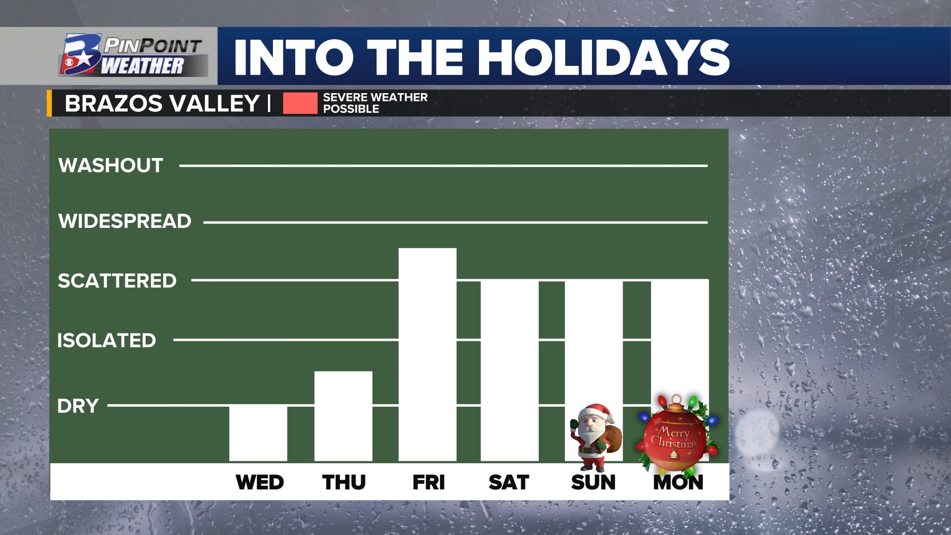
A series of disturbances look to swirl over the state by the holiday weekend, keeping things unsettled until a front arrives early next week.
While big lows headline the weather coast to coast, we’re under a lovely winter high pressure system through about Wednesday. High clouds start streaming in by midweek, and a southeast wind returns, loading up some lower level moisture. The west coast low slogs eastward at the end of the week and into the weekend, and several, smaller disturbances are set to swirl around that parent low before it ejects eastward early next week. This will allow for several different chances for scattered showers and thunderstorms from Thursday through at least Christmas Monday.
A series of disturbances look to swirl over the state by the holiday weekend, keeping things unsettled until a front arrives early next week.
What’s different from last time?
Last week’s system was a knockout uppercut – Rain(what little there was) front, wind, cold, done. This week’s will be a flurry of smaller jabs followed by a hook at the end that eventually brings in the drier, cooler, more stable air. Exactly where and when said jabs come is still to be determined, unfortunately, but we’re growing more confident that we will hit on at least a couple chances for rain before we start looking ahead to New Year’s.
A series of disturbances look to swirl over the state by the holiday weekend, keeping things unsettled until a front arrives early next week.
What will change
While the positioning of this low could end up being much farther north (leading to a much drier outlook) that does not look as likely as of now. The question at this point is not if, but rather when and how much as far as rain is concerned. There will also be a small potential for an isolated strong storm too. Numbers for totals and which days we’re most focused on will be fine tuned, but Friday and Christmas Eve look to bring the highest chances of rain as of early Monday.
Whether traveling across the state or staying home for Christmas, weather will likely impact you at some point through the long weekend.