Light at the end of the soggy tunnel: One more round of storms before we settle into drier pattern
BRYAN, Texas (KBTX) – Sunshine has been more than welcome the past day or so, but it’s time, once again, to look ahead to the NEXT chance for strong storms and flooding.
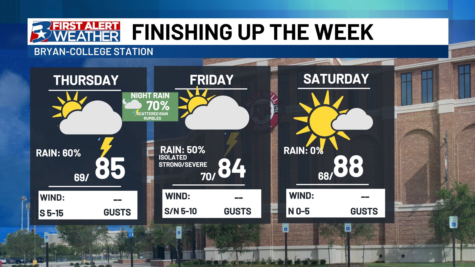
A strong trough of low pressure looks to pop up rain and thunderstorms to our north and west by Thursday afternoon. Those storms will then move south and eastward into the Brazos Valley as early as the PM rush hour. At least one more round is possible overnight into Friday, where rain chances generally look to wind down as we head into the weekend.
Two different outlooks issued by NOAA have highlighted the area for this disruptive weather potential. Of most concern is the Weather Prediction Center’s “Excessive Rainfall Outlook” that highlights most of the area in a 3 out of 4 risk for excessive rainfall. Essentially, it just means with conditions currently in place + the heavy rain potential, flooding is likely, potentially in a widespread fashion.
Flash flooding looks likely in at least a couple areas by Thursday night. The combination of over-saturated soils and expected heavy rain will compound the flooding risk.
Feeling like a broken record at this point, but the main risk continues to be flooding. The greatest risk for strong wind will be with the initial round of storms Thursday.
As we’ve said the past several storm systems, flooding remains our greatest concern through Friday afternoon, with the greatest risk falling along and east of Highway 6. Of most impact to driving may be the evening drive Thursday through at least the Friday morning rush hour. Should any storms pop up Friday, flooding will immediately be the biggest impact, but an isolated strong storm cannot be ruled out either.
Thursday afternoon/evening looks to bring the greatest coverage of rain/storms and highest risk for severe weather. An additional round of strong storms is POSSIBLE overnight into Friday morning, but most of Friday is expected to be quiet, unless we see additional development Friday afternoon.
Most high resolution data keeps us stable leading into the afternoon/evening Friday and keeps activity to our south. We are running with that solution at the moment.
And now, the “light” at the end of the tunnel
Almost forgot! After Friday, we look to get a well-deserved break from rain and storms that should last us at LEAST through this coming weekend, and likely for much of next week. Some models are hinting at additional dryline thunderstorms to our west that will need monitoring for evenings/overnights, but the general thought is we’re going to be on the outside looking in of heavier rain chances as a ridge sets up to our south, potentially shielding us from storms (but making things toasty) for the majority of next week.
A ridge looks to set up over northern Mexico next week. that COULD shield us from storms while the severe potential continues across the Plains next week.
A little farther south/weaker ridge means more storms. We’ll keep you posted, but right now, we’re trending drier and WARMER pic.twitter.com/dsp1i7vgW3
— Max Crawford 👍 (@KBTXMax) May 15, 2024