Isolated storms could produce gusty, damaging wind Sunday afternoon
BRYAN, Texas (KBTX) – A welcome rain chance returns to the Brazos Valley Sunday. The key word is “chance” as a weak front pushes a north wind shift through Central Texas Sunday afternoon. While most of this activity is expected to be more of a passing shower potential, a few thunderstorms may develop in the day’s intense heat. Heavy rain will rapidly cool that hot air, which is why the Storm Prediction Center has placed a majority of the area under a 1 out of 5 risk for a strong or severe storm through early evening.
SEVERE WEATHER POTENTIAL
The overall chance for impactful weather is low across Central and Southeast Texas as we close the weekend. Still, the Brazos Valley has been placed in the first low risk for severe weather in almost 50 days. The last time there was this kind of chance for thunderstorms locally: July 9th.
The Brazos Valley is under the first risk of strong/severe storms since early July
Any thunderstorm that manages to develop in the afternoon’s near 110° heat, will have the potential to rapidly cool the air temperature to the 80s or upper 70s. This quick change in temperature may develop strong, damaging wind gusts anywhere between 30mph and 65mph. Considering the distress this summer’s heat has caused area trees, even a non-severe wind gust below 50mph could have the potential to bring down large, weak limbs. Power outages or damage or damage to property is the main reason the agency has issued this risk for the Brazos Valley.
TIMING OF RAIN AND STORMS
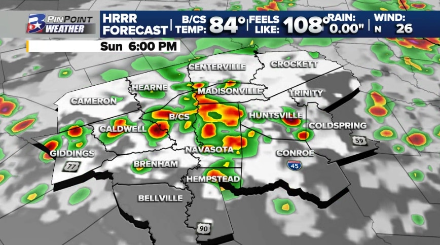
Plans between 3pm and 9pm? This is the main window for potential development Sunday.
A projection for what radar could look like Sunday afternoon and evening
The data above is likely too optimistic for the day’s actual coverage and potential. Still, use this as a guidance of timing and potential versus the exact location of when and where needed rainfall will occur. Any chance for wet or stormy weather should wane with the loss of the day’s heat. Radar trends are expected to be on a downward fall between 7pm and 10pm.