Historic Hurricane Beryl approaching Category 5 strength in the Caribbean
BRYAN, Texas (KBTX) – The first major hurricane of the 2024 Atlantic hurricane season is a record-breaking one. Monday evening, the storm officially reached Category 5 status.
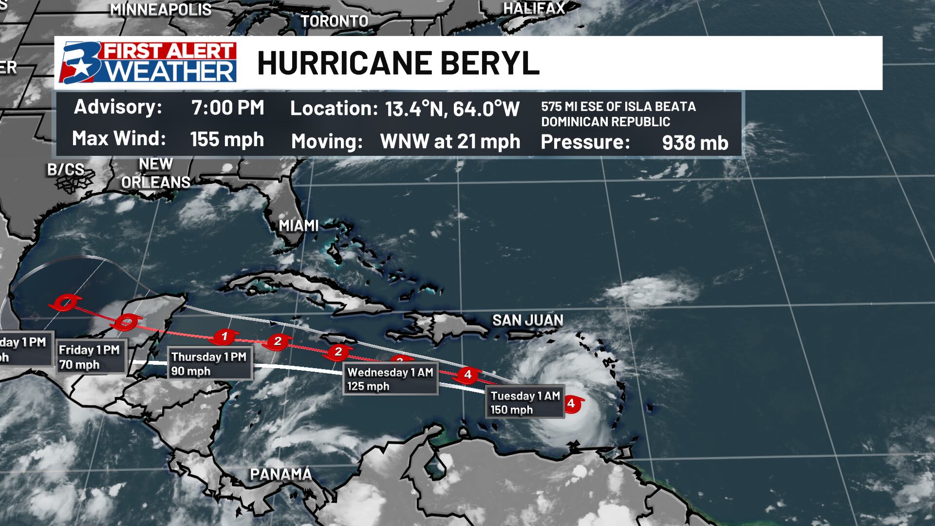
As of the Latest update from the National Hurricane Center:
Aircraft data found Beryl had wind speeds at Category 5 strength, making this the earliest storm of such strength on record.
#Hurricane #Beryl has intensified to a Category 5 hurricane with max winds of 160 mph – the earliest calendar year Atlantic Category 5 hurricane on record. The prior record was Hurricane Emily on July 17, 2005 at 0UTC. pic.twitter.com/QMrLonKM4F
— Philip Klotzbach (@philklotzbach) July 2, 2024
What’s next?
A Hurricane Warning is now in effect for Jamaica, with Tropical Storm Warnings lining the coast of both the Dominican Republic and Haiti. Beryl will continue on this west-northwest path until potentially interacting with Jamaica, then westward movement is expected toward the Yucatan Peninsula before the end of the week.
Beryl’s westward track and momentum will likely mean major impacts to at least parts of the Caribbean. Though the current forecast is for additional weakening as it nears the Yucatan Peninsula, interests in these areas will need to continue to watch this storm closely. If you have travel plans in any of these areas from now through the first week of July, keep a close eye on the forecast, flights and bookings, as this storm has the potential to disrupt a lot of travel over the next week or more.
Texas impacts?
While Beryl continues on this westward jaunt, we will continue to watch wobbles and model trends over the next week. A strong ridge of high pressure re-established itself over Texas this weekend and looks to expand over the Southeast over the course of this coming week. From there, models diverge on exactly how strong this ridge stays and where it is centered. Between questions about steering flow from said high-pressure ridge and individual path and strength of Beryl, it is too early to know of any impacts from the storm for the state of Texas.
The good news: Any potential impacts will likely wait until after the Fourth of July holiday, meaning we have plenty of time to assess data and any potential risk for Texas and the Brazos Valley. There are a few models beginning to reach into late this weekend/next week, but there is nothing definitive at this time that should lead to concern for the state of Texas.
Regular updates can be found on air, online, and on your First Alert Weather app. If you want to track the storms along with the team you can pick up the 2024 First Alert Weather Team Hurricane Tracking Chart at any of our sponsors, or download it here!
Satellite technology has advanced to the point where you can now see ocean waves in the eye of Major Hurricane #Beryl 🤯 https://t.co/bMrirPtAzQ
— Mike Ventrice (@MJVentrice) July 1, 2024