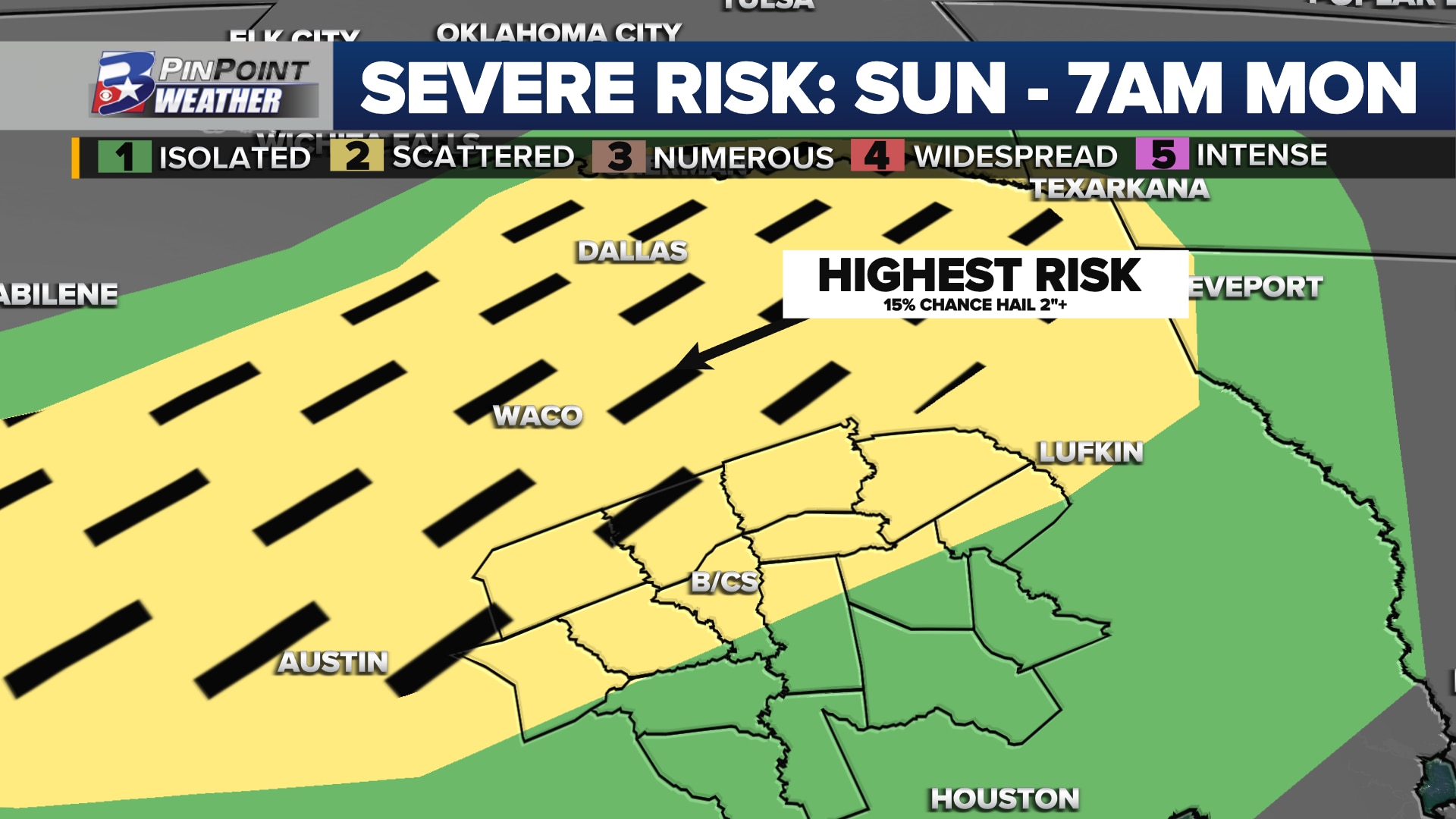
Brazos Valley marked for potential severe weather Sunday night – early Monday
BRYAN, Texas (KBTX) – A weak cold front is headed to the Brazos Valley as we start this final week of September, helping to push thermometers away from the triple-digit mark. Ahead of that wind shift, thunderstorms are expected to fall out of North and Central Texas, into the Brazos Valley in the very early, pre-sunrise hours Monday. The Storm Prediction Center has placed the northern Brazos Valley under a 2 out of 5 risk for a few strong to severe thunderstorms.
WHAT: Strong-to-severe thunderstorms arriving from the north. While not every thunderstorm is expected to be concerning, some could prompt severe thunderstorm warnings through the middle of the night. A severe thunderstorm watch could be issued ahead of these anticipated storms, if the National Weather Service deems it necessary.WHEN: Generally between midnight and sunrise Monday. This could come in two rounds of activity: first between 12am and 4am, with a second round between 5am and 8amWHERE: Highest potential for impactful weather is expected along and east of I-45, particularly with the initial round of storms moving south out of Central Texas. Additional, more widespread rain and storm activity will be possible through the overnight further west into other portions of the Brazos ValleyIMPACTS: Damaging or strong wind gusts up to 40mph or higher. Any discrete storm that manages to move out of Central Texas could produce large hail between the size of a quarter or a small sporting ball (ping pong, golf ball, etc) although this is a much lower risk locally. Heavy or repeating rain could create localized areas of minor, low-lying, or street flooding that could cause a few issues for the Monday morning commute.
Any strong or severe storm could bring wind gusts over 40mph to parts of the Brazos Valley. A few storms may create a brief hail concern at times.
Early afternoon take on how storms could rattle the Brazos Valley overnight – the very early hours of Monday morning.
One thing to monitor: some data has storms ETA as early as 9pm – 11pm. Think it is an outlier but worth keeping an eye on pic.twitter.com/6EoFGaAI9O
— Shel Winkley 👍 (@KBTXShel) September 24, 2023
The forecast radar above is not perfect, but it gives a very good example of how this weather event could play out through the overnight hours. There are some data sets that suggest scattered storms could reach parts of the northern or northeastern Brazos Valley a few hours sooner, potentially as early as 9 to 10pm Sunday. While this is more of an exception rather than the overall consensus, it is something that will be monitored with trends as storms develop in North and Central Texas between 5pm and 7pm.