Another round of storms likely to bring additional flooding, especially east of Highway 6 corridor
BRYAN, Texas (KBTX) – Friday afternoon through Saturday brought a much needed break from rain across most of the Brazos Valley, but another round of storms may have us right back in the thick of it by Sunday morning.
Like yesterday (and the day before) numerous severe storms are expected to develop west of I-35 this afternoon, where they will likely congeal into a line and move eastward through the overnight. While last night’s thunderstorms eroded before reaching us, we’re currently expecting enough momentum for tonight’s storms to arrive in the pre-dawn hours Sunday.
Widespread rain and thunderstorms are expected by or before sunrise Sunday, with another, less heavy, round possible through the day.
Widespread rain and thunderstorms are expected by or before sunrise Sunday, with another, less heavy, round possible through the day.
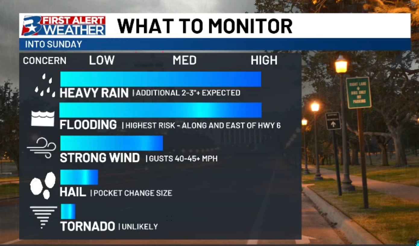
The above is a (not perfect) look at what the radar could look like before and as we’re waking up Sunday morning. This will be the round most worth watching for severe weather (including strong wind as the main threat) and additional heavy rain that could cause or exacerbate already existing flooding issues through the rest of the day.
Widespread rain and thunderstorms are expected by or before sunrise Sunday, with another, less heavy, round possible through the day.
While it is difficult to troubleshoot exactly where flooding issues will be the greatest through the end of the weekend, travel on already flooded roads will likely continue to be the main issue headed into next week. Those who have had water flooding yards, pasture, or even moving into their homes may unfortunately see that worsen before we hopefully get several days of drier weather leading into next week.
If you have travel plans Sunday or Monday, remember to check drivetexas.org before you head out so you can plan your travels accordingly. During high impact, longer lasting events, this is typically your best way to see how road conditions are in your area.
Many have been asking (and for good reason) about Highway 6 over the Navasota river on the southern edge of Brazos County. We will update on kbtx.com if and when water actually spills over the highway, but it’s better to approach any bridges with extreme caution for the next week or so, just to be on the safe side.
Next week looks much drier than the week previous, but we will once again be in “watch, wait, and see” mode with strong thunderstorms to our north. Any storms we see locally or upstream could cause continual issues for flooding, especially on and near the Brazos, Navasota, and Trinity rivers.