A soon-to-be-hurricane in the Pacific brings Texas a chance for rain next week
BRYAN, Texas (KBTX) – October is an important month for the Brazos Valley. For starters, it is the time of year cooler, fall weather starts trickling far enough south to have Central and Southeast Texas reaching for long sleeves once again. As that autumn air arrives and cold fronts flip a north wind around, typically a rain and thunderstorm chance comes with it. The tenth month of the year is the one that, climatologically speaking, usually brings the most rain to the area.
On average, Bryan-College Station expects to receive about 5″ of rain in October. So far, this month has managed to create three measurable days of rain, totaling 2.62″ at Easterwood Airport. As of October 17th, the month-to-date rainfall is behind by 0.30″. A tropical system in the Pacific and a late-month cold front will attempt to play catch-up ahead of Halloween festivities.
TROPICAL STORM NORMA
Late Tuesday afternoon, the National Hurricane Center started issuing advisories on the latest tropical storm to form in the Eastern Pacific. Named Norma, the storm with 40mph wind was located 445 miles south-southwest of Manzanillo, Mexico. This system will slowly meander north through the week, strengthening into a Category 2 hurricane on Thursday. It is then forecast to graze the southern tip of the Baja region before turning northeast toward the northwest coast of Mexico.
Norma is forecast to strengthen into a hurricane before making landfall early next week
After making landfall, the rough, craggy terrain will quickly weaken Norma to a remnant low with the associated moisture pointed toward parts of West Texas and the Southern High Plains.
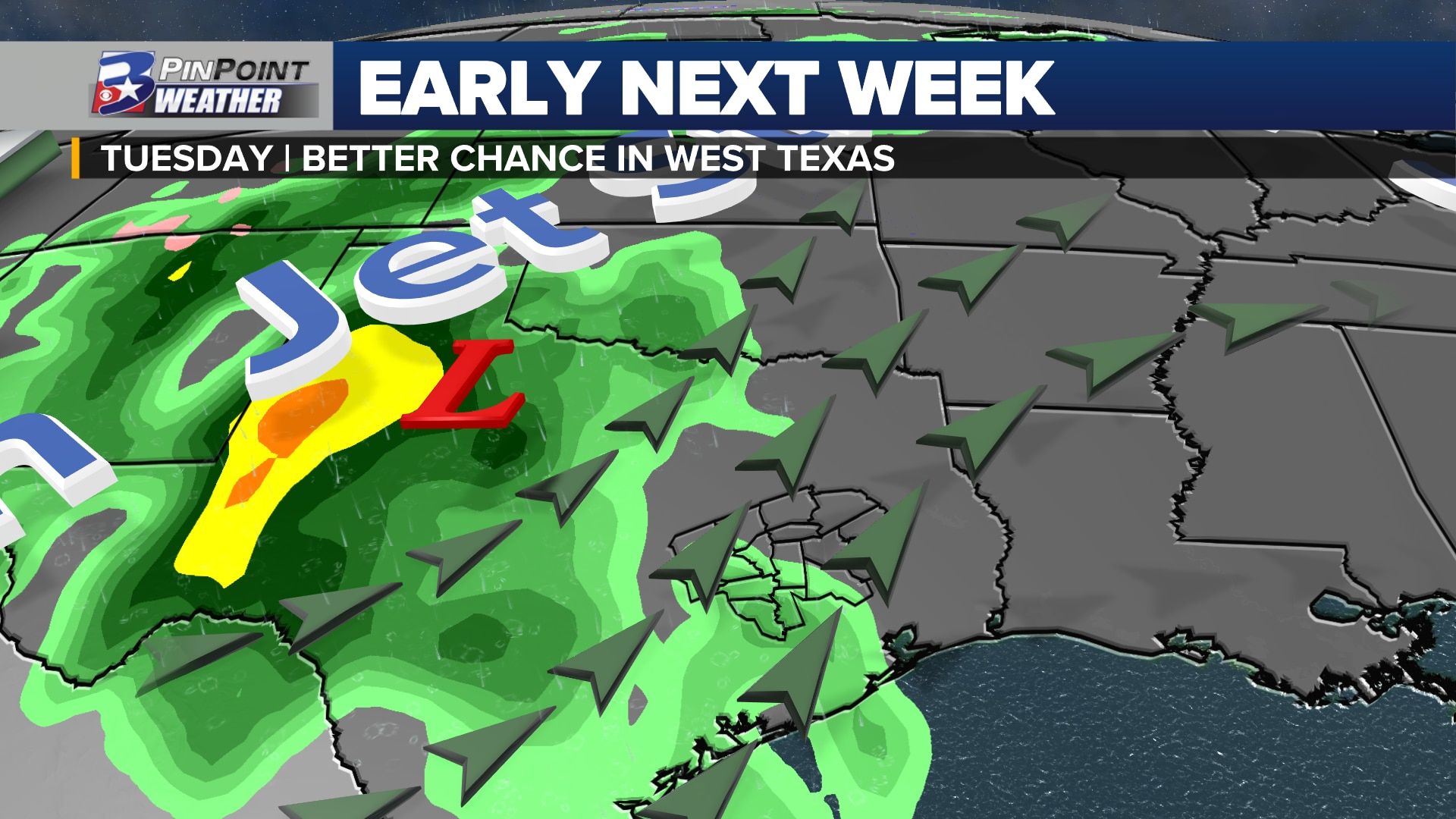
WESTERN UNITED STATES WEATHER MAKER
Pulling the remnants of Norma into Texas: a deep digging area of low pressure. Upper-level winds are expected to run over northern Mexico and the western side of Texas. This brings the potential for the heaviest rain to fall in the western reaches of the state starting late Monday and continuing Tuesday.
A deep digging area of low pressure over the Western US will pull Norma over Mexico and into Texas
As much as 1″ to 3″ of rain is possible somewhere between the Big Bend Region to Lubbock to Midland and Abilene. The heaviest rain potential depends on where this remnant area of Norma tracks.
For the Brazos Valley, the chance/coverage of rain Tuesday is on the low end: 30%. Upper-level winds will “diverge” over East Texas, promoting the chance for scattered showers to form. Still, any rain that manages to fall should only amount between 0.05″ and 0.25″ by sunrise Wednesday.
BETTER CHANCE OF RAIN 8 TO 10 DAYS FROM NOW?
…the Climate Prediction Center seems to think so.
The Climate Prediction Center currently gives the Brazos Valley higher-than-average odds for rainfall before the end of the month
The agency, part of NOAA and the National Weather Service, currently gives the Brazos Valley a 40% to 60% chance for above-average rainfall anytime between October 25th and Halloween. While not set in stone, the signals are there in the forecast data that rain becomes a better possibility ahead of the last weekend of the month.
As the big area of low pressure west of Texas — that pulled Norma to the northeast — finally swings across the mid-section of the country, the next cold front is loosely scheduled to arrive somewhere around Thursday the 26th or Friday the 27th. This front is the best chance for rain and thunderstorms locally, as it clashes with lingering mid-level moisture from the Pacific and low-level moisture being spoonfed out of the Gulf of Mexico. While too early to speculate on rainfall totals, some early forecast data has suggested anywhere from 1″ to 3″ of rain could fall over parts of Southeast Texas.
General trends to follow when monitoring a weather system in the long term forecast
The signals for the next big weather maker are in the forecast data. The next 5 to 7 days will be spent looking for consistency and slowly working on the potential of where, when, and how much. Details, as we know them, will be posted here to KBTX.com and in the KBTX PinPoint Weather App.