As Beryl moves west, monitoring for Texas impacts
BRYAN, Texas (KBTX) – Beryl has already etched itself in the history books in a number of ways, but a gradual weakening trend is expected over the next several days and into this weekend/next week. From the Caribbean, we first watch for potential landfall in Jamaica. From there, an additional landfall somewhere over the Yucatan Peninsula is expected.
From there? We likely see Beryl move into the Bay of Campeche or Gulf of Mexico. Beryl’s strength and path to and from that point are still very much to be determined, and its potential impacts on the state of Texas are, too. For more on Texas, scroll down.
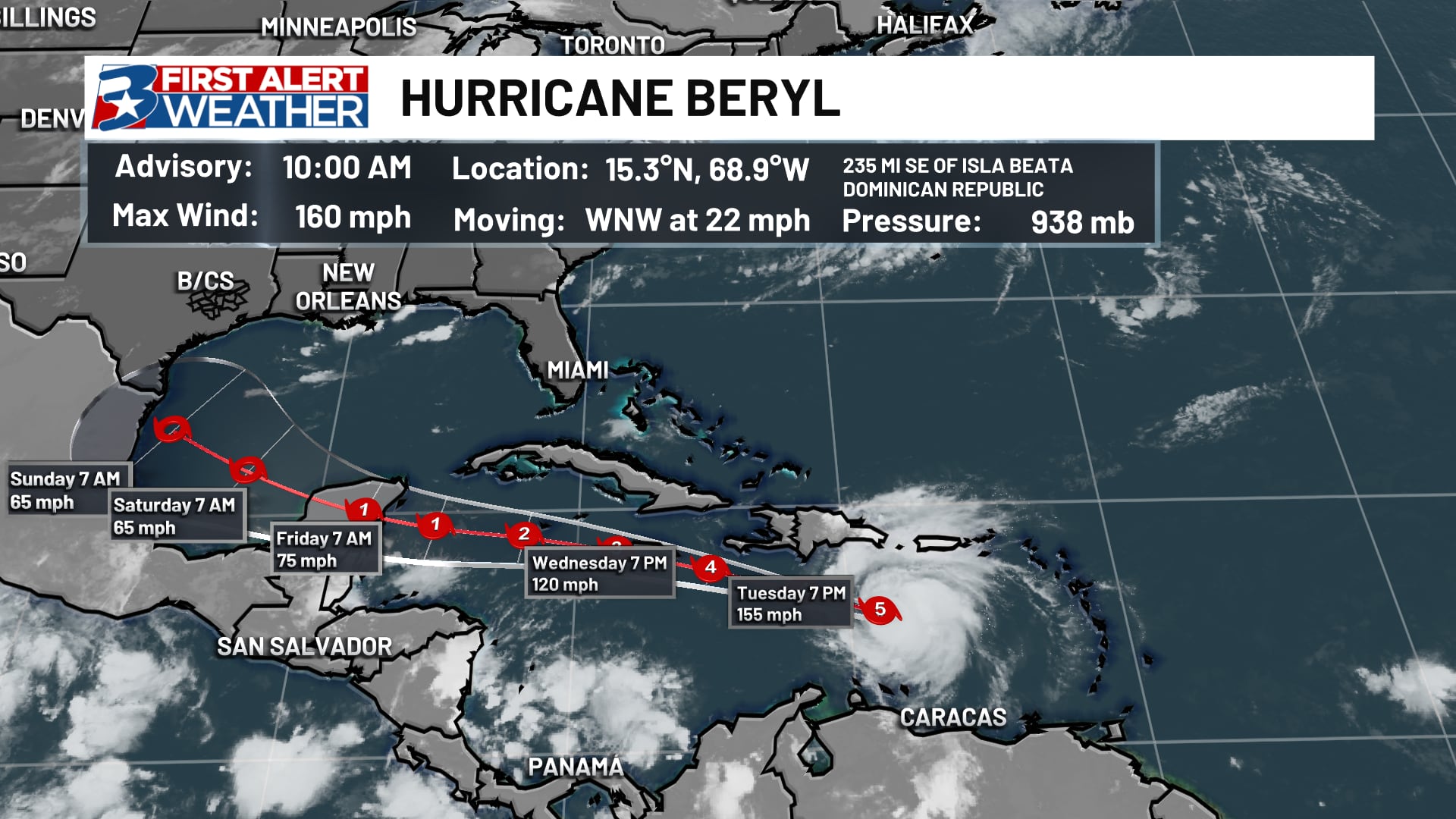
As of the Latest update from the National Hurricane Center:
Beryl is beginning a slow weakening trend that is forecast to continue over the next several days, as it encounters some unfavorable upper level winds and likely interacts with land from Jamaica to the Yucatan.
Animation of Hurricane Beryl’s intensity evolution alongside storm-following GOES-East infrared satellite imagery from 18 UTC 28 June to 12 UTC 2 July.
The brief weakening period shown in this graphic was associated with an eyewall replacement cycle (ERC). pic.twitter.com/5DI5TCNzMb
— Dr. Kim Wood (@DrKimWood) July 2, 2024
What’s next?
A Hurricane Warning is in effect for Jamaica, Hurricane Watches are in effect for Grand Cayman, Little Cayman, and Cayman Brac, and Tropical Storm Watches are in effect for portions of the Dominican Republic and Haiti.
Beryl is moving quickly to the west-northwest, with a well-established ridge over the southern US this track will continue to steer Beryl across the Caribbean for the next few days. At least some interaction with Jamaica is expected, with a major hurricane landfall not being ruled out, as per a couple different hurricane-specific weather models provided by the NWS. Beyond that, the latest track has been nudged ever so slightly to the north. The agency notes the increased uncertainty in the track beyond Friday as the storm moves into the Gulf of Mexico.
Texas impacts
A ridge of high pressure will play a large role in what exactly Beryl does once it does move into the Gulf. This ridge is expected to weaken as we approach the weekend. Ahead of ANY potential interaction with Beryl, this may open the door for some showers and storms from North Texas to the coast, including our area. From there, additional moisture from Beryl, or rain bands from the storm itself, could come into the state right as the holiday weekend is ending and we start next week. Between land interaction, track, and strength of Beryl, it is too early to know specific impacts, but at least some appear more likely, with rough surf/waves expected along the coast.
There is plenty we don’t know, but a few things that are becoming clearer (and will become MUCH clearer) regarding Beryl and Texas in the coming days.
What to watch
• Path of Beryl
• Strength of Beryl
Both the intensity and movement of Beryl will play a huge role in whether Texas and the Brazos Valley see impacts from this storm. A more northward track, combined with a stronger Beryl, would mean more rain and wind locally. Should Beryl not make a direct landfall over the Yucatan (more northward movement), or only skirt the northern tip of the peninsula, that would likely result in less weakening of the storm, bringing a greater concern for a Texas hurricane landfall. While this is in the realm of possibilities, it appears to be the less likely scenario as of right now.
A more southerly track would likely reduce impacts and overall strength of the storm. At the moment, we are expecting landfall to be anywhere between the northern Mexico coast to the Middle Texas Coast. This is a very large spread, so confidence in potential Texas impacts remain low.
There is plenty we don’t know, but a few things that are becoming clearer (and will become MUCH clearer) regarding Beryl and Texas in the coming days.
Where do we go from here? Watch, wait, monitor trends, and remain calm. As of Tuesday afternoon, Beryl presents no major concern for the Brazos Valley. Rainfall forecasts will largely depend on the above (strength and path of the storm).
As we get more information and confidence in the forecast, we will, of course, keep you updated. Regular updates can be found on air, online, and on your First Alert Weather app. If you want to track the storms along with the team you can pick up the 2024 First Alert Weather Team Hurricane Tracking Chart at any of our sponsors, or download it here!