Shortly after Monday’s solar eclipse, significant storms expected in the Brazos Valley
BRYAN, Texas (KBTX) – Millions of eyes will be turned to the sky Monday as a total solar eclipse crosses the United States from Texas to the Northeast. After the protective eyewear is removed, focus will shift to the radar as strong to severe thunderstorms are possible for the Brazos Valley as early as mid-afternoon.
SEVERE WEATHER CONCERNS
The Storm Prediction Center has the entire Brazos Valley outlined in a 2 out of 5 “scattered” risk for significant or severe thunderstorms. Within that risk, the area has been placed in a “hatched” hail outlook, meaning there is a “10% or greater chance of two-inch or larger hail within 25 miles of a point” in the outlook area. To be fair, the agency has covered much of Texas in both of those risks, considering the remaining uncertainty of where clusters of storms will develop.
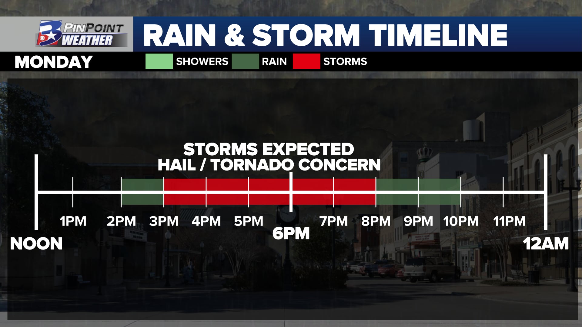
TIMING: 3pm to 7pm MondayAREAS WITH THE HIGHEST IMPACT CHANCE: Central and Northern Brazos Valley, generally from Highway 21 to the northPOTENTIAL IMPACTS: Large hail, potentially as big as an egg, is the main concern. Rotating thunderstorms could also create a tornado concern within the most significant storms. Damaging wind gusts 40-60mph are possible, potentially reaching speeds as high as 70mph.
WHY THESE STORMS CAN DEVELOP
Sunday brought a weak cold front, and a few very light showers, across the Brazos Valley. That front will turn around and head to the north as a warm front Monday afternoon. As unstable air surges in from the Gulf of Mexico, this boundary can help add the lift to push thunderstorms up, rapidly developing into strong or severe storms. This boundary will also change the wind direction from the ground to the mid-levels of the atmosphere. Due to that wind shift, any storm that can become established will have an opportunity to rotate and create instances of hail, at least to the size of a quarter or half dollar, but potentially as large as an egg.
After the eclipse Monday, the first of at least a couple different rounds of rain and thunderstorms will move through the area, with some severe weather possible. The main risk will be for large hail, but damaging wind and a tornado or two cannot be ruled out.
The good news for trying to get a view of the solar eclipse crossing the Brazos Valley sky between noon and 3pm — with maximum eclipse happening around 1:40pm — is clouds may break by late morning to allow some sunshine through. The flip side of that: the same clearing will allow the sun to destabilize the atmosphere and develop storms along the northbound warm front.
Sunday morning data for viewing conditions of Monday’s Solar Eclipse
RECEIVE SEVERE WEATHER ALERTS AND CHECK INTERACTIVE RADAR WITH THE KBTX PINPOINT WEATHER APP
Below is Sunday morning’s data for what the radar could look like. While it is not perfect on where storm placement will occur, it does help plan for the day and understand where the highest concern will be ahead of sunset Monday.
Showers and storms are expected to form in the Central Brazos Valley and move northward from mid/late afternoon. Biggest thing we’ll need to monitor: Some storms will be capable of large hail, and we can’t rule out a tornado. pic.twitter.com/tZY8vS7ZPX
— Max Crawford 👍 (@KBTXMax) April 8, 2024
Storms will not impact all of us, but it is an afternoon that we all need to monitor. Traveling for the Eclipse to the north or west? Keep in mind that you very much have a chance to run into significant storms on your drive home.
Rest of the week – Additional rounds of showers and storms are expected as a strong trough of low pressure moves over the state by midweek. While we are stewing in this warm, humid atmosphere, another round of storms is POSSIBLE Tuesday, but more likely Tuesday night into the early morning hours Wednesday.
After the eclipse Monday, the first of at least a couple different rounds of rain and thunderstorms will move through the area, with some severe weather possible. The main risk will be for large hail, but damaging wind and a tornado or two cannot be ruled out.
After the eclipse Monday, the first of at least a couple different rounds of rain and thunderstorms will move through the area, with some severe weather possible. The main risk will be for large hail, but damaging wind and a tornado or two cannot be ruled out.
This looks to be our most widespread chance for rain and storms. All types of severe weather will be possible, but the primary threat will be for hail and wind once again.
The good news: We will clear things out in short order Wednesday. Other than an isolated storm Wednesday afternoon, we look to remain quiet through the rest of the week.