Strong storms expected Thursday
BRYAN, Texas (KBTX) – Clouds are set to return Wednesday as we await a rowdy round of weather Thursday, thanks to a Pacific weathermaker rolling in tomorrow. This system links up with that deep slug of tropical moisture Thursday, prompting the potential for a few bumps in the form of rain and thunderstorms as we close out the month of November. These may even try to take on a spring-like feel as we monitor for a chance at a few strong-to-severe storms on Thursday.
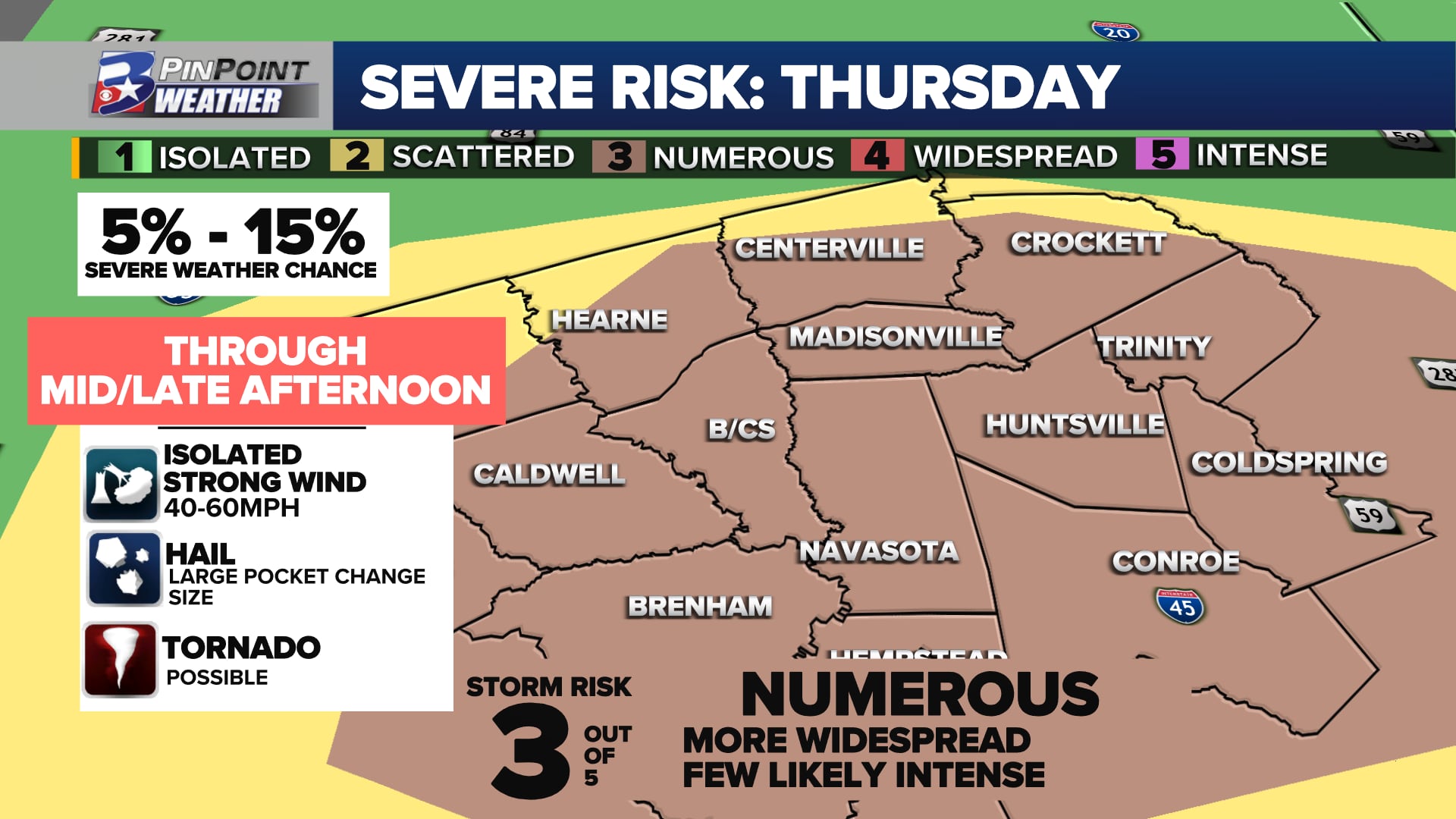
Widespread rain and storms (a couple severe) are expected before the end of the day Thursday. The primary threat is strong wind, but tornadic storms cannot be ruled out.
THE NUTS & BOLTS
Showers and storms associated with a big low pressure system is moving onto the West Coast early Wednesday, and will cover a LOT of ground eastward over the next 24 hours. This is the next upper-level storm system that will swing across the Western United States to reach Texas by Thursday. It also kinks the jet stream into a favorable position to allow for rain and thunderstorms to lift and form west and on top of the Brazos Valley.
Two different weather features will link up mid-to-late week to bring a chance for rain and storms back to the Brazos Valley
At the same time, a slug of deep tropical moisture is lurking in the far Southern Gulf of Mexico. This will be picked up by the upper-level winds and sideswipe Southeast Texas between Wednesday and Friday. This increase in atmospheric moisture will set the stage for the potential for heavy rainfall during this event.
STRONG-TO-SEVERE STORMS ARE NOT PROMISED, BUT CERTAINLY NOT RULED OUT
Rain and thunderstorms are possible as early as the pre-sunrise hours Thursday morning. Overcast skies and the chance of an early round of scattered showers will likely keep a “cap” — basically limiting factors — for thunderstorms to build and reach the greatest instability the atmosphere holds early in the day.
As for the severe chance…it’s not ruled out but is highly dependent on the cap above our heads. This is the limiting factor to stronger storm development. If we can tap into it, especially in the afternoon, we’ll need to watch for all modes of severe weather locally. pic.twitter.com/66fAiEwbNT
— Kayleigh Thomas (@KBTXKayleigh) November 28, 2023
Breaks in the clouds by early afternoon will allow for temperatures to rise into the 70s and the atmosphere to destabilize. The high moisture content, combined with daytime heating and lift along the front, will provide some fuel for storms to develop. As winds increase and turn in direction with height, this will create “spin” in the atmosphere conducive for rotating and potential supercell thunderstorms. If storms manage to break past the limiting factors and tap into these dynamics, all types of severe weather would need to be monitored for, including:
Damaging, strong wind in excess of 40-60mphA tornado or twoLarge hail between the size of a quarter and an egg in diameterFrequent lightningMinor street or low-lying flooding
As of Wednesday, the Storm Prediction Center has placed most of the Brazos Valley in a 3 out of 5 risk for severe weather, particularly late morning through early afternoon. While widespread rain is expected, the atmosphere may support a couple of supercell thunderstorms, which will be capable of producing some strong winds or even a couple tornadoes.
Widespread rain and storms (a couple severe) are expected before the end of the day Thursday. The primary threat is strong wind, but tornadic storms cannot be ruled out.
The main concern with this setup: Thunderstorms that form may turn severe quickly, bringing little warning. Storms will need to be watched for quick “tightening” of rotation, which could quickly spawn brief, but strong tornadoes. Thursday will be a day to keep about your regular plans, but have a way to receive weather alerts and be aware of your surroundings.
TIMING
We still expect the bulk of activity (and the biggest severe potential) to be from mid-morning through mid-afternoon. Late in the day and in the evening, we should quickly wind things down and step into a mainly quiet Friday and weekend.
Widespread rain and storms (a couple severe) are expected before the end of the day Thursday. The primary threat is strong wind, but tornadic storms cannot be ruled out.
HOW MUCH RAIN ARE WE TALKING ABOUT HERE?
There is plenty of tropical moisture to tap into as this next rain event passes through Central and Southeast Texas. While rainfall totals are not expected to be uniform area-wide, 0.25″ to 1″ of rain very well could be common. Stronger thunderstorms could release a quick 1.5″ to 2″ as they race from west to east. These storms should be quick movers — storm motion is currently forecast around 40 mph. Overall flooding concern is low, but the typical haunts when heavy rain falls in a short amount of time will need to be monitored. For this reason, the majority of the Brazos Valley is also included in the Excessive Rainfall Outlook for Thursday as well.
As we get closer to this event, confidence has grown that several ingredients for severe weather will be in place, but this is still a conditional risk, where we’ll be constantly coming over new data into Thursday. Updates can be found as we have them here on KBTX.com, in your KBTX PinPoint Weather app, and on-air.