Brief window for possible severe storms Monday ahead of stout cold front
BRYAN, Texas (KBTX) – Turkey Week travel starts with a quick severe weather chance across the Lone Star State, then some MUCH cooler weather for the rest of the week. All in all, we don’t expect severe weather to be a big part of your Monday, but there is enough of a concern through at least mid-afternoon.
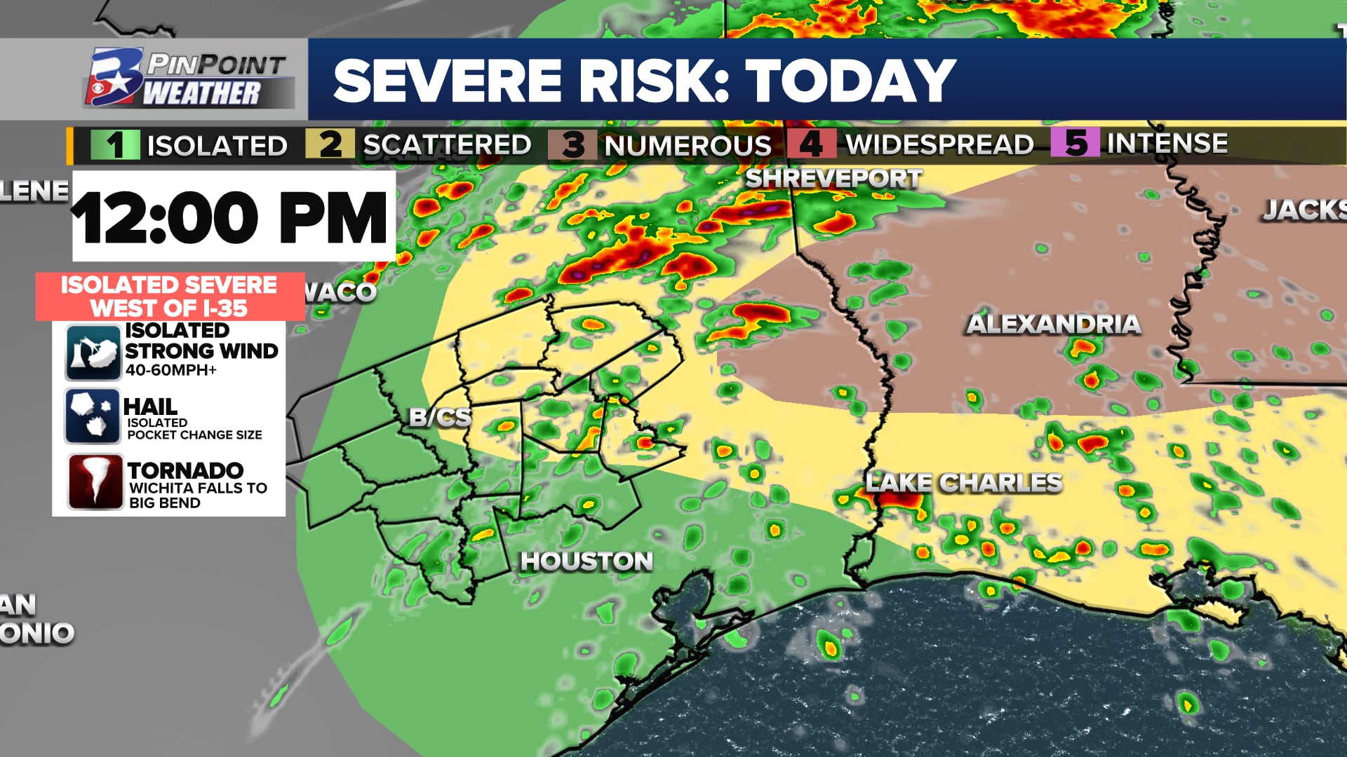
WHAT THE STORM PREDICTION CENTER SAYS AS OF MONDAY MORNING
Most of the Brazos Valley has been included in a 1 out of 5, isolated, risk for severe weather (shown in green above). A slightly higher 2 out of 5, scattered, risk has been expanded to include a little more of the Brazos Valley (including portions of Brazos and Robertson counties east of Highway 6) as of the Monday early morning update.
The agency notes that if thunderstorms manage to become concerning, large hail and locally damaging wind gusts will be the primary, initial threats. They go on to note that there is a chance of a tornado threat potentially evolving with persistent supercell thunderstorms — although that is more likely east of the Brazos Valley.
A few storms Monday could be briefly strong-to-severe as they pass through the Brazos Valley
TIMING AND POTENTIAL LOCALLY
The chance for rain and a few thunderstorms is possible as early as about 9am today. This initial activity could produce passing heavy rain, small/sub-severe hail, wind gusts to 30mph, and occasional lightning. If this timing holds, this round of rain and storms would likely be non-severe.
CHECK THE LATEST RADAR AND RECEIVE ALERTS AS THEY ARE ISSUED WITH THE KBTX PINPOINT WEATHER APP
By midday to early afternoon, a few stronger storms will attempt to form along or east of I-45 as the heating of the day starts to take hold. By this point, most storm activity should be moving east and out of the Brazos Valley into East Texas. This is where the more likely potential for severe weather starts to materialize, particularly as storms move further east into Louisiana.
Forecast radar for late Monday afternoon as storms move east of Texas
The overall concern for severe weather is low, but not necessarily zero for the Brazos Valley.
HOW MUCH RAIN COULD FALL MONDAY
New data this morning continues to be modest in terms of accumulated rain. While not all forecast data is supportive of this round of storms starting over the Brazos Valley, the most aggressive outputs sprinkle the area with needed rainfall.
Rainfall totals between 0.1″ and 0.25″ should be common if this rain opportunity materializes. The northern and northeastern Brazos Valley — where training or stronger storms are possible — has the chance to grab localized totals between 0.5″ and 1″.
KEEP TUNED THROUGH MID-AFTERNOON
Though the overall expectation is for today to remain mainly quiet, there are enough ingredients present in the atmosphere to warrant caution today. Cooler, windy weather is set for tonight and into Tuesday, but there are no more storm concerns through the rest of the week after this afternoon.