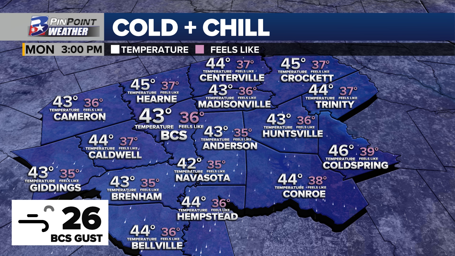
MONDAY: Dress for the 30s. Dress for rain.
BRYAN, Texas (KBTX) – February 2nd. 270 days is how long it has been since the Brazos Valley has experienced the chill that Monday brings. A combination of an early-season Canadian cold front, thick overcast skies, blustery north wind, and light rain will hold thermometers to the 40s for the first time since last winter.
DRESS FOR THE 30s
Now that the highly advertised and anticipated cold front has passed, a brisk north wind is howling in behind to usher in this new, winter-ish air mass. Wind gusts 30-35mph are expected to blow through sunrise Monday. That wind and — mostly — low 40° start temperatures will make it feel like 32° to 35° as you step out the door for the day. Monday morning gusts to 30mph should be common before a slight decrease to 25-30mph for the afternoon.
Hour-by-hour forecast for a rainy, cloudy, brisk Monday, October 30th
Morning rain, clouds, and wind will likely keep thermometers static from sunrise to lunchtime. At best the day is expected to “warm” about 2° to 3° into the mid-40s. That will keep the feels-like temperatures sub-40° for much of the area from sun-up to sun-down. Bundle up! Brrrrrrr
Monday could be the second coldest October 30th of record in Bryan-College Station
By the way, Monday’s projected high of 45° would make this the second coldest October 30th in Bryan-College Station’s 141 years of record keeping. Since those records were moved to Easterwood Airport, there has not been a second to last day of October colder than 47°.
WIDESPREAD LIGHT RAIN
Overrunning. That is the process that will allow light, steady rain to fall from Sunday night through — at least — the first half of Monday.
Cold, Canadian air that moved into the Brazos Valley Sunday is taking up the lowest part of the atmosphere.
Warmer, humid air is “overrunning” the dome of cold. That + the passing base of this weather maker will allow light rain to fall tonight & through Monday pic.twitter.com/BMjFbYeF0A
— Shel Winkley 👍 (@KBTXShel) October 30, 2023
CHECK INTERACTIVE RADAR AS LIGHT RAIN FALLS ACROSS THE BRAZOS VALLEY TUESDAY
The cold air that moved into our area Sunday is shallow and located the lowest levels of the atmosphere. Riding up and over this cold air: warmer, humid air from both the Gulf of Mexico and the Pacific Ocean. As the base of a digging weathermaker swings past Texas Monday, this allows steady light and occasionally moderate rain to stream west to east across our part of Texas.
Steady rain starting Sunday night brings the chance for as much as 1″ or more of rain to parts of the Northern & Central Brazos Valley
End result? As much as an inch of rain or more across the farthest north reaches of the Brazos Valley to as little as 0.25″to 0.50″ of rain for the furthest south portions.
CLEARING OUT IN TIME FOR HALLOWEEN
Spotty, light rain and drizzle will linger in the forecast Monday night through mid-morning Tuesday. Skies are expected to quickly clear from north to south Tuesday between mid-morning and early afternoon. Crisp sunshine closes the work and school day as ghosts and goblins take to the streets on a candy hunt. A slight wind chill and temperatures in the mid-to-upper 40s are expected for any post-sunset Halloween festivities.