Get Ready. Winter air arrives in the Brazos Valley Sunday
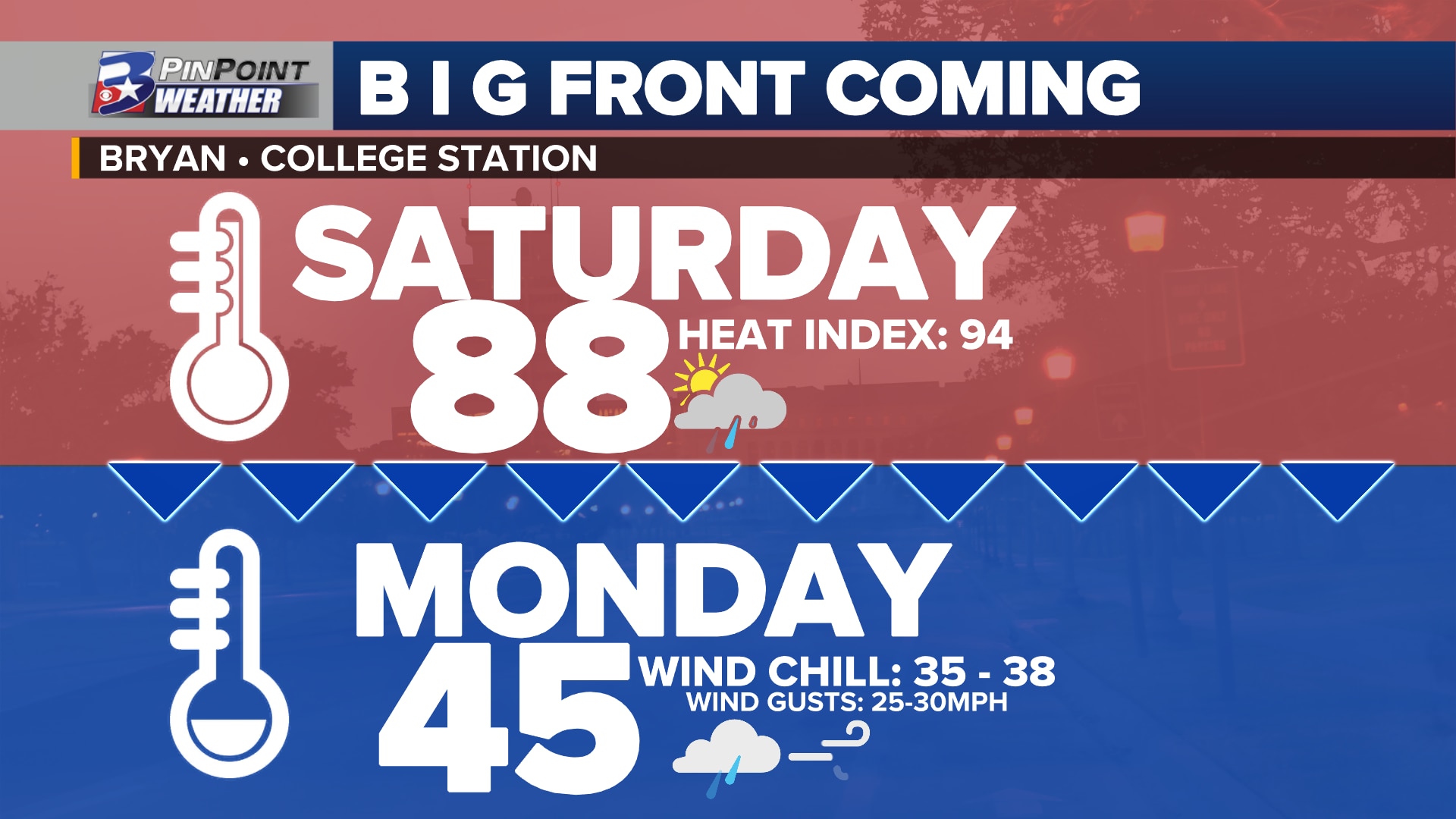
BRYAN, Texas (KBTX) – Put the shorts and t-shirts away. Dig around the back of the closet for the big coats. The first blast of winter air is set to reach the Brazos Valley between mid-morning and late afternoon Sunday. By Monday, everyone is dressing like it is the mid-30s before walking out of the door for the day.
SUNDAY IS COLD FRONT DAY
For the first time this season, temperatures will abruptly drop as a sharp north wind blows Canadian air in through the day. Daytime highs in the mid-to-upper 70s and low 80s will occur between midday and early afternoon before thermometers start tumbling. As the cold front arrives, expect a 10° to 15° drop within the first hour. 5pm temperatures are expected to range between the upper 40s in north-northwestern Brazos Valley to the 60s in the far south and southeastern reaches of the area.
Spotty morning showers will have a chance to consolidate along the leading edge of this cold air by late morning to midday. Quick, scattered downpours may pass by as the welcoming committee for this exchange of summer-like to winter air.
Hour-by-hour forecast for Sunday, October 29th and Monday, October 30th
MONDAY: COLD. BRISK. WIND CHILLED. DAMP.
Interested in wind chill values in the mid-to-upper 30s? A blustery 25 to 30mph wind gusting through the day will make it feel that cold as it peaks throughout the day, particularly in the morning.
Forecast temperatures (white) and wind chills (pink) throughout the day Monday, October 30th
Actual temperatures are expected to either hold steady, or slip a degree or two, due to overcast skies and consistent drizzle/mist/light rain. New rainfall accumulations are expected between 0.25″ and 0.75″ between sunrise and sunset Monday.
HEADED OUT FOR TRICK-OR-TREAT FESTIVITIES? CHECK THE SPOOKY DETAILS IN THE KBTX PINPOINT WEATHER APP
Forecast wind gusts Monday, October 30th
GARDENERS BEWARE! LIGHT FROST / FREEZE POSSIBLE LATER IN THE WEEK
Clearing skies take over for Halloween, paving the way for frigid mornings as November begins. Current low temperatures are expected in the low-to-mid 30s Wednesday and Thursday morning. The first frost and potential light freeze is expected for much of the area Tuesday night / Wednesday morning and again Wednesday night / Thursday morning.
Sensitive and tender plants will likely need protection or to be brought indoors to survive the week. Pets will also need a warm place to sleep.