90s in October?! Let’s put the Brazos Valley’s incoming fall heat wave into perspective
BRYAN, Texas (KBTX) – The Brazos Valley has been enjoying full-blown fall since a strong cold front passed through Central and Southeast Texas late last week. After four days of well-below-average temperatures and the chilliest reading (so far) of the season, thermometers are about to make a big flip. Afternoon highs are expected to run as much as 10° to 15° above average to close out the work week and through weekend plans.
A “DON’T CALL IT A COLD” FRONT
A passing weather system way up north over the Great Lakes will drag a front through the Brazos Valley, flipping a north-northwest wind in by mid-to-late Thursday afternoon. This so-called “cold” front is not expected to bring any colder air to Texas, but rather very dry air. The jet stream — how weather is moved across the country — has been pushed into the southwest corner of Canada, where temperatures are pleasant — upper 60s / low 70s — but above-average for this time of the year. By the time that very mild air reaches the Lone Star State, there is not much “cool” left to it.
Afternoon highs are expected 10° to 15° above average for mid-to-late October
B I G TEMPERATURE SWINGS
Mornings feel like fall through the start of the weekend. As you walk outside, it will seem every bit like a mid-to-late October start to a day. By afternoon, summer-like weather is in full control as highs catapult to the low and mid-90s.
Dry air will cause large temperature swings to occur through the weekend
The dry air that this cold front ushers in is exceptionally good at cooling rapidly once the sun goes down. That will allow Thursday, Friday, and Saturday mornings low to fall to either side of 60° at sunrise. The average at this time of the year is 60° on the dot. However, dry air is also very good at warming up rapidly under a bright, blue, sunny sky — even with the sun angle that October provides. That will allow afternoon temperatures to swing anywhere from 30° to 40° above what morning thermometers read.
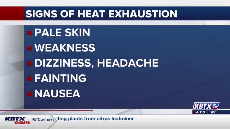
Get out early. Take it easy in the afternoon heat.
RECORD HEAT EXPECTED FRIDAY AFTERNOON
The hottest temperature experienced on October 20th in Bryan-College Station’s 141 years of record keeping? 94° in 2019 — four short years ago.
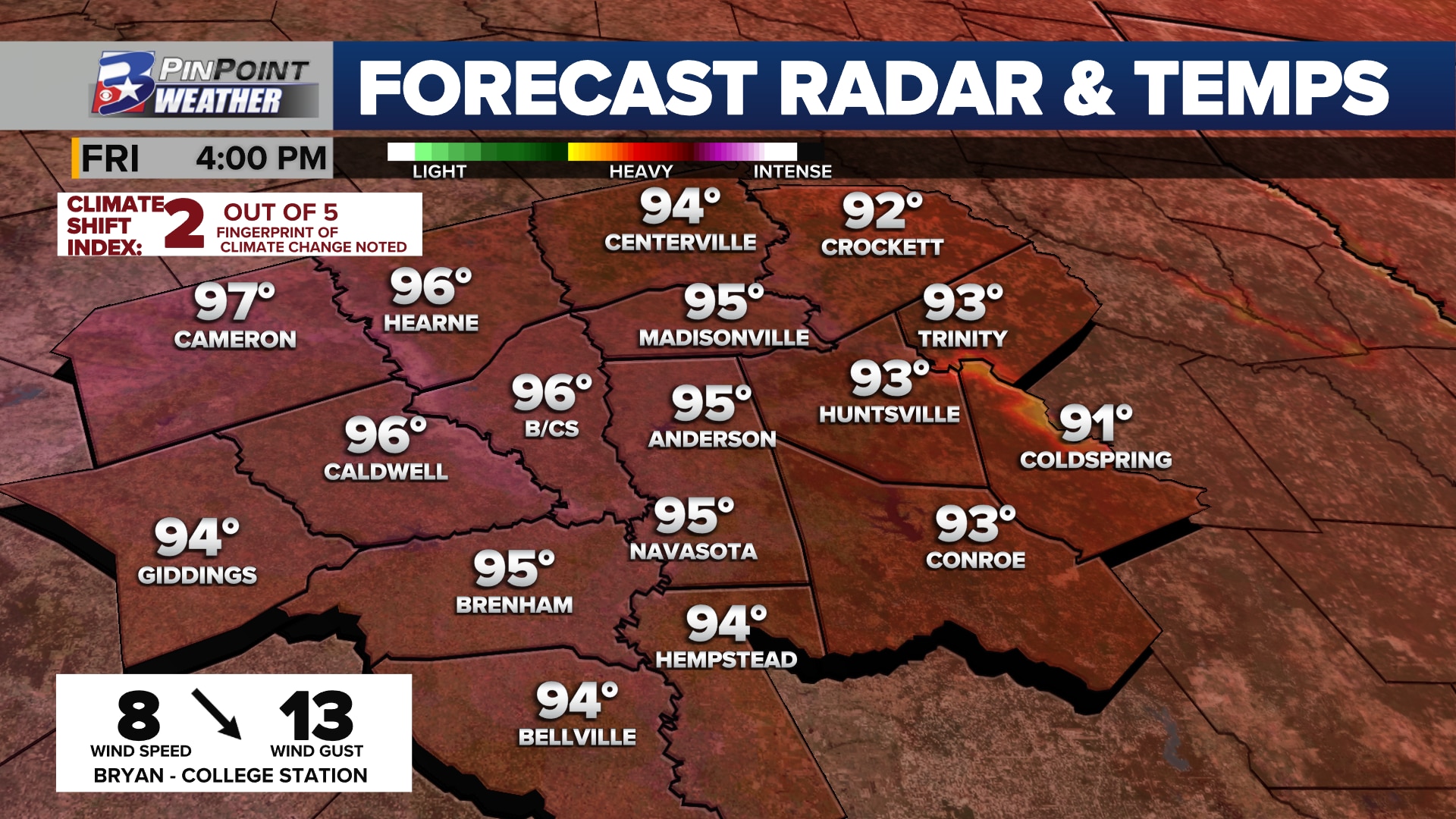
Record heat is expected in Bryan-College Station Friday afternoon
That record is expected to be surpassed and replaced by 2023. The current forecast — as of Wednesday night — is a high of 96° at Easterwood Airport. It would also tie the hottest temperature of record for October 20th through the end of the year with October 30th, 1927.
Saturday’s anticipated high temperature of 94° is not expected to be record-setting, but it will come mighty close. The current record high for October 21st was set back in 1934 at 95°. This would also be the only time since 1882 that a high of 94° was reached on this day in Bryan-College Station.
Attribution science data, courtesy of Climate Central, shows us that record heat like this is two times more likely to occur at this time of the year, with this type of weather pattern, due to the impacts of human-induced climate change.
90s ARE NOT COMMON, BUT NOT UNHEARD OF IN LATE OCTOBER
The latest 90° temperature on record in Bryan-College Station belongs to November 16, 1921. While not common, here are how many times 90° or hotter has been recorded on each of the dates for the upcoming fall heat wave:
October 19th: 7 timesOctober 20th: 8 times October 21st: 10 timesOctober 22nd: 11 times
An influx of tropical moisture and cloud cover is expected to warm mornings closer to/over 70° while trending afternoons back to the mid and upper 80s through much of next week. The next push of fall air is not expected to reach the Brazos Valley until closer to the final weekend of the month.