Drizzly, damp weather possible thanks to trio of tropical systems
BRYAN, Texas (KBTX) – Weekend and early week sunshine will be muddled by mid-to-high level moisture sweeping over Brazos Valley skies Tuesday and Wednesday. Three tropical areas of interest — one in the Gulf of Mexico and two in the Eastern Pacific — will bring the area a chance for passing patchy areas of drizzle, mist, and light rain through mid-week.
Monday Night PinPoint Forecast: Overcast, drippy skies expected for the Brazos Valley between Tuesday afternoon & midday Wednesday.
Here’s the latest on the trio of tropical interests changing things up around here: pic.twitter.com/Ub5A2UEMHV
— KBTX Weather (@KBTXWeather) October 10, 2023
WHAT TO EXPECT
Mostly cloudy skies are expected to greet the Brazos Valley at the start of the day Tuesday. From those clouds, spots of light, passing rain will be possible by or after 3 p.m. Initially, a few decent showers with higher rain rates could start this event as the leading edge of activity arrives from the west.
By evening, scattered, light rain is expected at times, moving from the west to the east. Any chance for moderate rainfall is expected further south, mainly in Austin, Waller, Montgomery, San Jacinto Counties and I-10 to the south. This rain chance will continue into the overnight hours.
Wednesday morning’s commute will likely continue to feature these light patches of rain. Other than the need for occasional windshield wipers and wet streets, travel issues are not expected due to the weather. By early to mid-afternoon, any chance for damp conditions will begin to come to an end from the west-northwest to the southeast.
CHECK INTERACTIVE RADAR BEFORE HEADING OUT WITH THE KBTX PINPOINT WEATHER APP
HOW MUCH RAIN COULD FALL?
Not much. In fact, probably not enough to justify this article (but here we are). Any measurable rain is expected to be very light and totals small. At best, a few hundredths to about a tenth of an inch will be common for those who manage to collect water in the gauge. Higher totals around 0.25″ or so are possible further south and closer to the Houston Metro area.
The Brazos Valley is estimated to need another 7″ to 10″ of rain to ease and rid the ongoing drought conditions. While damp and soggy, this “rain” event is not expected to dent the situation.
WHAT IS CAUSING THIS CHANGE IN THE WEATHER?
Three things:
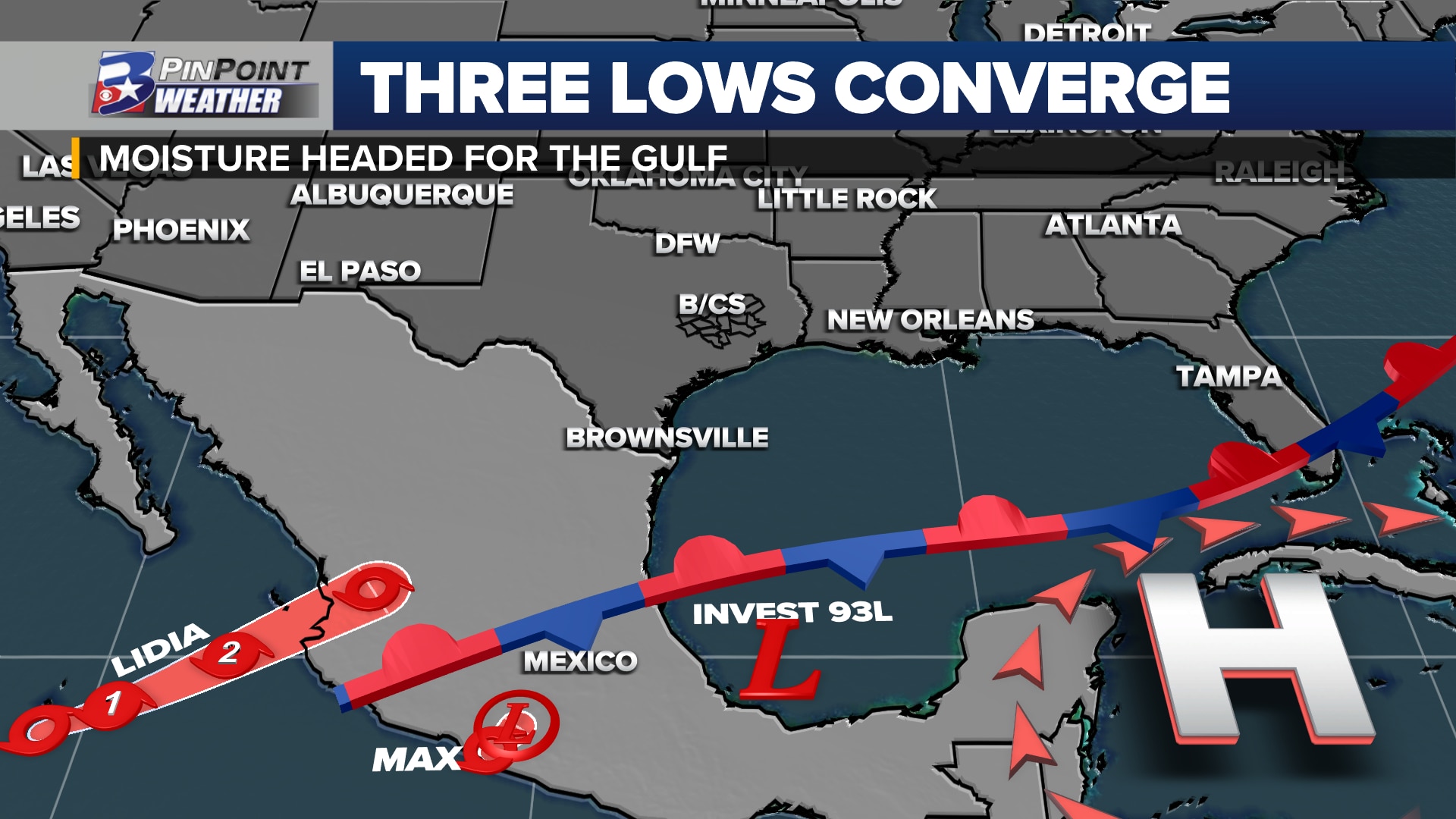
Invest 93-L: The National Hurricane Center tagged an area of low pressure in the Southern Gulf of Mexico / Bay of Campeche first thing Monday morning. An agitated area of cloudiness and thunderstorms continued Monday evening. According to the agency, “environmental conditions appear only marginally favorable for some additional development while the system moves slowly northward during the next day or so. The low is forecast to merge with a frontal system over the western Gulf of Mexico by Wednesday morning.” Forecast models drift this area of interest toward the northeast Gulf of Mexico by mid-to-late week
Tropical computer models are now fully running for #93L in the Southern Gulf of Mexico.
No big surprises: development or not (probably not) the associated slug of tropical moisture will widely bypass Texas and head for the northeast side of the Gulf Coast pic.twitter.com/6L9vrtX1mR
— Shel Winkley 👍 (@KBTXShel) October 10, 2023Tropical Storm Max: This short-lived system moved inland to the west of Puerto Vicente Guerrero Monday afternoon. Maximum wind speeds were on the low end of a tropical storm at 40mph at the time of landfall, extending outward 60 miles from the center. This is expected to rapidly weaken overnight, dissipating into a remnant low by Tuesday. The moisture associated with this system will then be picked up by upper-level winds and moved toward the Gulf of Mexico, almost in sync with Invest 93-L.Tropical Storm Lidia: This system is expected to become a hurricane Tuesday night before strengthening to a Category 2 storm ahead of landfall late Tuesday/early Wednesday. This is the main driver of the rain chances moving into the Gulf of Mexico, eventually driving all of the rain-making tropical moisture to the northeastern Gulf of Mexico. As the remnant low of Lidia approaches from the southwest, the scattered light rain / drizzle chance will continue for the Brazos Valley. As Central and Southeast Texas fall to the north and west of this low pressure, dry air wrapping around the counter-clockwise flow will eventually dry up the rain chance locally from west-northwest to the southeast.