RECORDS SCORCHED: Unprecedented heat turns Summer 2023 into the Brazos Valley’s all-time hottest
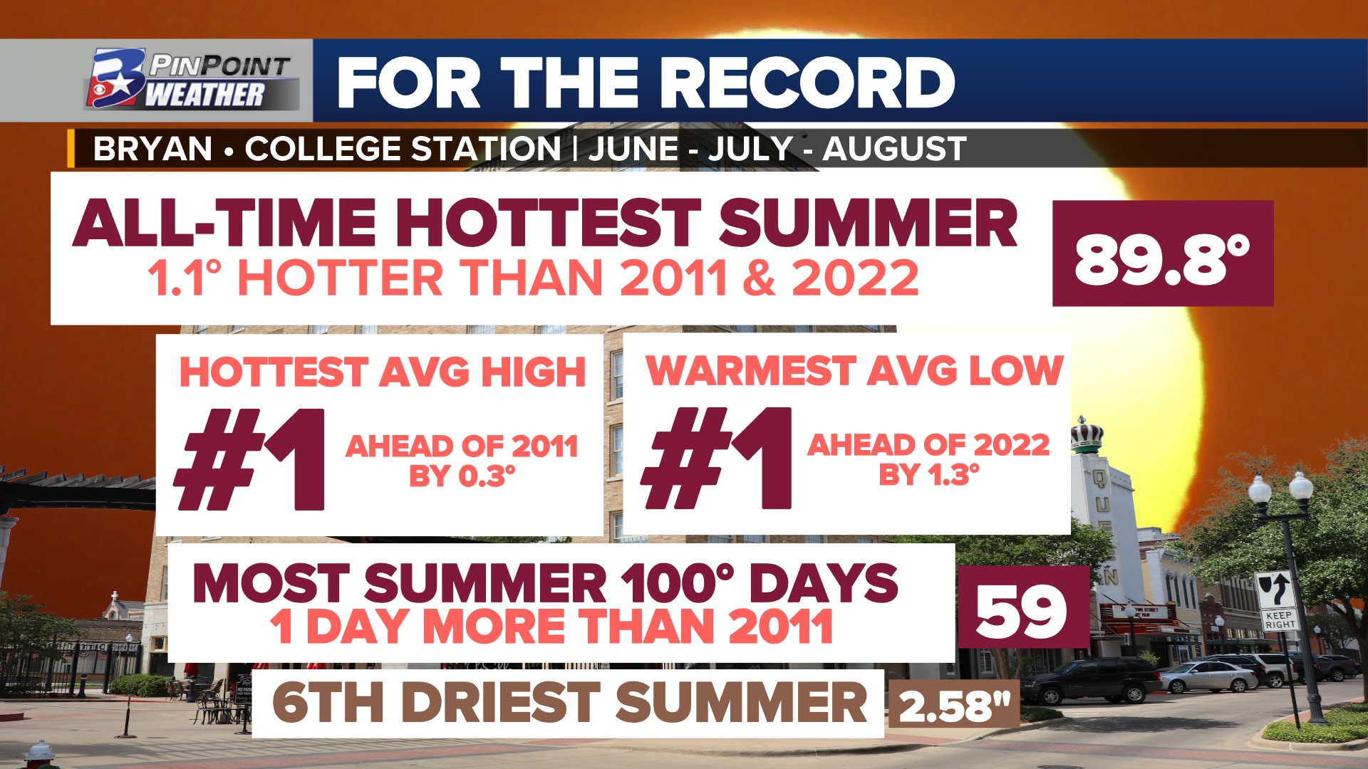
BRYAN, Texas (KBTX) – August 31 officially ends what is known as “Meteorological Summer.” 184 days of brutal, unrelenting, continuous, and unprecedented heat that not only rose through the record book but completely rewrote it. Summer 2011 was previously the benchmark for heat locally and across Texas until Summer 2022 tied with it. Multiple months of triple-digit days, consistent, above-average nighttime warmth, and one of the top ten driest on record: Bryan-College Station just experienced the all-time hottest summer in 141 years of record keeping.
For climatological record keeping, the National Weather Service and NOAA consider “summer” to comprise the 92 days of June, July, and August. Any reference to summer in this article refers to this definition.
With all 184 daytime highs and overnight lows considered, summer 2023 ends with an average temperature 89.8° above the previous top summers of record. Here is how the past three months brought the Brazos Valley to this point:
The average temperature for the past three months ended at 89.8°Typically, summer in the Brazos Valley settles around an average of 84.5°This summer ended 5.3° above where the past 30 years of weather suggest it shouldJune was the sixth hottest of record with an average of 85.9°. This was 1.7° below the all-time hottest on record, which was set last year (2022)July was the second hottest of record with an average of 90.2°. This was 0.7° below the all-time hottest on record, which was set last year (2022)August was the all-time hottest of record with an average of 93.3°. This was 2.4° above the previous top record, which was set in 2011 (12 years ago)August became the all-time hottest month ever of record in Bryan-College Station’s history. This was 2.4° above the previous record that was set in July 2022 (1 year ago)2023 ended with the hottest average for high temperatures ever recorded in a summer seasonAn average high temperature of 101.0° exceeded the previous top spot in 2011 by 0.3°2022 ended with the absolute warmest average for low temperatures ever recorded in a summer seasonAn average low temperature of 78.6°exceeded last year’s (2022) record of 77.3°by 1.3°August 20th and 27th’s high temperature of 112° tied the all-time hottest temperature of record from September 4, 2000The summer ended with the most 100° days in the three-month period. At 59, this breaks the previous record of 58 days from 2011 (12 years ago)The longest-running, consecutive stretch of triple-digit days occurred between July 9th and August 27th. At 50 days this is now the all-time record, replacing the old record of 30 days from 1998 (25 years ago)The longest-running and second longest-running consecutive stretch of 105° or hotter days were set in Summer 2023.The record longest-running, consecutive stretch of 105° or hotter days is now set at 15 days (July 31st – August 14th)The second longest-running, consecutive stretch of 105° or hotter days is now set at 11 days (August 17th – August 27th)The previous record for consecutive 105° or hotter days was 7, set back in 2000As of August 31st, 59 days of triple-digit heat have been recorded at Easterwood Airport. Currently, this is the second most experienced in a year, behind the current record of 69 set in 2011 NOTE: more triple-digit highs are forecast as the month of September begins18 Record High temperatures were set or tied in Summer 2023As of August 31st, 26 days of 105°+ heat have been recorded at Easterwood Airport. This is now the all-time record, replacing the previous record of 12 set back in 2011 (12 years ago)As of August 31st, 3 days of 110°+ heat have been recorded at Easterwood Airport. This is now the all-time record, replacing the previous record of 2 set back in 1903 (120 years ago) and 2011 (12 years ago)As of August 31st, 45 nights of 80°+ warmth have been recorded at Easterwood Airport. This is now the all-time record, completely overshadowing the previous record of 29 set back in 1902 (121 years ago) NOTE: more low temperatures at or above 80° are forecast as the month of August begins34 Record High Minimums (warmest low of record) were set or tied in Summer 2023With a total of 2.58″ of rain, Summer 2023 was the sixth driest summer of record in Bryan-College Station. This was 1.94″ more rain than what fell in Summer 1980, the driest summer of record.June officially left behind 1.87″ of rain at Easterwood AirportJuly officially left behind 0.65″ of rain at Easterwood AirportAugust officially left behind 0.06″ of rain at Easterwood Airport. This is the fourth driest August of record with 0.06″ of rain more than what fell in August 1902, the driest August of record.
By the end of August, the Brazos Valley fell into some of the worst drought conditions in recent summers. The drought monitor released on August 31 notes the entire area was experiencing Stage 3 of 4, Extreme Drought, conditions as the season comes to a close. June’s 1.87″ of rain fell between the 3rd and 10th of the month. Dry conditions prevailed until 0.64″ of rain fell on July 6th, making up all but 0.01″ of the month’s rain. No measurable rain was reported between July 8th and August 24th. It is during this time, that the Brazos Valley went on a 50-day run of consecutive triple-digit heat.
RECORDS FROM SUMMER 2023
RECORD HIGH MINIMUMS (Warmest Low Temperature of record)
RECORD HIGH TEMPERAUTRES
FINGERPRINTS OF HUMAN-INDUCED CLIMATE CHANGE
While July and August helped race 2023 to the top of the list of all-time hottest summers of record, overnight warmth is the underlying reason for the exceptional heat. Warming nights are one of the top signals of a warming, changing climate during the summer months. Typically, a calendar year brings only a handful of mornings at or above 80°. Attribution science tells us that a majority of the nighttime warmth experienced in June, July, and August was made five times more likely by climate change.
The average low summer temperature has warmed near 4° over just the last 50 years in Bryan-College Station
Since 1970, the average summer low temperature has increased by nearly four degrees. 50 years ago, the average summer temperature was expected to end the season in the low 70s. That average is now near or above 75°. Last summer, the average low temperature was 77.3°. This summer’s 78.6° by and far exceeds any summer night’s warmth for as far back as written and model data can reliably determine.
The average summer high temperature has warmed near 4° over just the last 50 years in Bryan-College Station
In just the last 50 years, Bryan-College Station has seen an average summer temperature increase of nearly three and a half degrees. Since 1970, on average, the Brazos Valley now experiences 42 more above-average days than just 50 years ago. In 1970, about 20 days between June and August were considered above average. As of 2022, that number has increased to 60 expected above-average days or roughly 65% of the season. Only seven afternoons this summer were considered average or below average. That means, 92% of summer 2023 afternoons were considered to be above-average compared to the 30-year average.
Another aspect of human-induced changes that likely have impacted Bryan-College Station specifically: Urban Heat Island effect. The addition of concrete, buildings, and the removal of green space can cause highly developed city space to experience peak temperatures as much as 15° to 20° hotter than nearby areas with more trees and less pavement. Recently, Climate Central noted that on average, Bryan-College Station may be up to 6° warmer than surrounding, rural portions of the Brazos Valley. Within the city, residents living near or next to a park will be cooler than residents living next to parking lots, the highway, or in high-rise apartment complexes.
Note: Rainfall and temperature data observations began on the campus of Texas A&M College in May 1882. Records were sporadic from 1882 to 1907 and no records are available for 1908 and 1909. Reliable records are available from 1910 to present. Observations began on the campus of Texas A&M College in May 1882. The station was relocated to the Texas Agricultural Experiment Station main farm located seven miles southwest of the College Station Post Office in January 1954. This station closed April 30, 1958. Other rainfall and temperature observations were taken in Bryan at 2310 23rd Street from September 1, 1913 through March 31, 1947. A weather station was established at the College Station FAA Airport (originally referred to as Bryan CAA Airport) in August 1951. The FAA Airport Station is now known as Easterwood Field.
The 30 year climatological averages are from the College Station FAA Airport (Easterwood Field) but the extremes and other temperature and rainfall records are from all sources.
The observation site has not moved since 1951 and remains at Easterwood Field.