Unprecedented heat continues…but with a hint of short-lived “relief”
BRYAN, Texas (KBTX) – 36 days of consecutive 100° afternoons. 14 consecutive afternoons that Easterwood Airport has reached a high of 105° or hotter. 36 mornings at or above 80° so far this year. Summer 2023 is on pace to end as the all-time hottest summer in Bryan-College Station’s 141 years of record keeping. Yep. Even exceeding last summer’s heat which tied the current record previously held alone by 2011. While we cannot snap all the records the Brazos Valley is currently living through, a subtle change this week should end at least one of them.
WHAT THIS FRONT IS:
A drop in humidityA drop in afternoon highs above 105°A drop of low temperatures below 80°
WHAT THIS FRONT IS NOT:
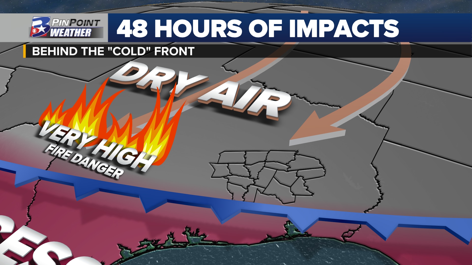
A fire danger remedyA rainmakerLong-lasting
DON’T CALL IT A “COLD” FRONT, BUT…
Monday brings the Brazos Valley another day of record heat by afternoon. The current hottest August 14th on the books is from 1951 when the afternoon high reached 106°. 2023 should not only get there again, for only a second time in history, but exceed that mark by 1°. This will be the 11th record high that August 2023 has claimed.
Forecast temperatures by 5pm Monday across Texas
To the north of the Brazos Valley, highs are expected to escape the triple-digit mark in the Metroplex, if not by just a degree or two. Head up to the I-40 corridor and the combination of clouds and a north wind have thermometers pausing in the 80s!
After thunderstorms pop-up and fall down on this wind shift across Central Texas, missing the Brazos Valley ahead of sunset, this front of sorts will pass through our area as we sleep Monday night. Tuesday is still a h.o.t. day topping off in the triple digits area-wide. So where is the benefit? This should be the first day since July 30th that does not end in a high temperature at or above 105°, ending the longest streak of record at 15 days.
Forecast temperatures Tuesday afternoon across Texas
The heat stays, but the humidity falls. When you walk outdoors and under a shade tree Tuesday, the air will actually feel like what the thermometer says, maybe even a degree or two “cooler.” Same case Wednesday. We drop a handful of degrees and gain a “dry heat” in the wake of this so-called cold front.
OVERNIGHT LOWS BELOW 80°
The last time it could be said that the area experienced a low temperature at or even near the expected average was early July, after the one day of rain the month yielded helped cool things off.
Temperatures drop below 80° at sunrise and 105° by afternoon for a few days.
Wednesday and Thursday are not only forecast to start in the 70s, but with lower humidity, it may actually feel refreshing for most. Wednesday’s low temperature of 75° would be the first “average” morning the area has had the pleasure of walking out to in about 40 days.
Get it while you can. Gulf moisture surges back in Thursday. Morning lows are back at/above 80° with “air-you-can-wear” by Friday.
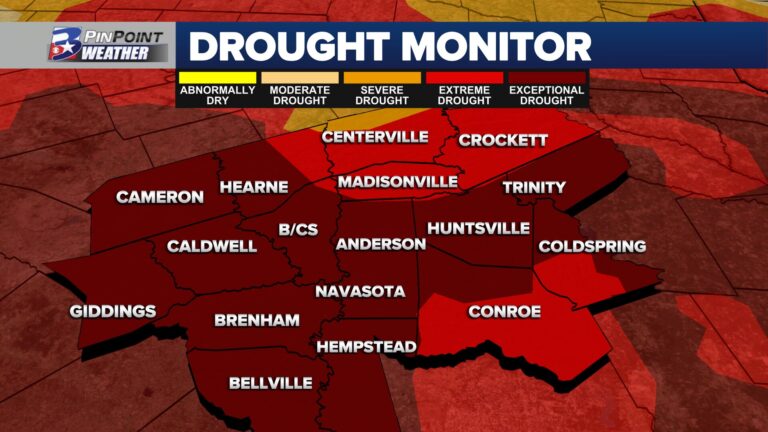
CRITICAL FIRE DANGER CONTINUES
While it may feel a touch better to walk outside, this lower humidity/drier air the north wind is pushing in will only elevate the grass/wildfire danger yet again.
Forecast fire danger Tuesday and Wednesday for the Brazos Valley
The Texas A&M Forest Service has marked a majority of the Brazos Valley under a 4 out of 5 Very High fire danger for both Tuesday and Wednesday. Burn bans continue across all 16 counties in the area. Outdoor burning remains prohibited.
Muggy air is scheduled to seep back in Thursday, pushing the heat index value back up to the 110° mark. Weekend plans? Heat Advisories and Excessive Heat Warnings are expected to return as feels-like conditions are forecast between 112° and 115°.